You are here: Home > Network List > AK - Alaska Regional Network Stations List
> Station COLD Coldfoot Broadband > Earthquake Result Viewer
COLD Coldfoot Broadband - Earthquake Result Viewer
| Earthquake location: |
Southeast Of Loyalty Islands |
| Earthquake latitude/longitude: |
-22.5/173.1 |
| Earthquake time(UTC): |
2016/08/12 (225) 01:26:35 GMT |
| Earthquake Depth: |
10 km |
| Earthquake Magnitude: |
7.2 MWW, 7.6 MI |
| Earthquake Catalog/Contributor: |
NEIC PDE/NEIC COMCAT |
|
| Network: |
AK Alaska Regional Network |
| Station: |
COLD Coldfoot Broadband |
| Lat/Lon: |
67.23 N/150.20 W |
| Elevation: |
377 m |
|
| Distance: |
93.5 deg |
| Az: |
13.475 deg |
| Baz: |
213.613 deg |
| Ray Param: |
0.041241 |
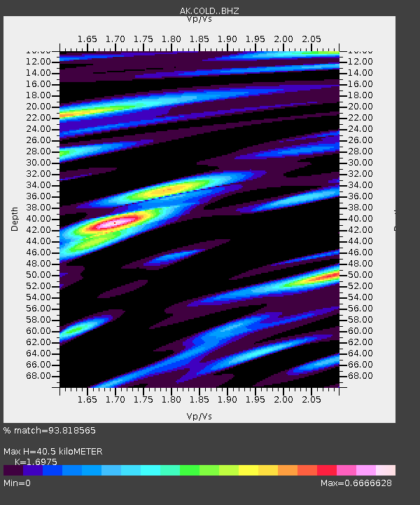
| Estimated Moho Depth: |
40.5 km |
| Estimated Crust Vp/Vs: |
1.70 |
| Assumed Crust Vp: |
6.577 km/s |
| Estimated Crust Vs: |
3.874 km/s |
| Estimated Crust Poisson's Ratio: |
0.23 |
|
| Radial Match: |
93.818565 % |
| Radial Bump: |
400 |
| Transverse Match: |
88.013725 % |
| Transverse Bump: |
400 |
| SOD ConfigId: |
11737051 |
| Insert Time: |
2019-04-25 06:03:49.677 +0000 |
| GWidth: |
2.5 |
| Max Bumps: |
400 |
| Tol: |
0.001 |
|

Signal To Noise
| Channel | StoN | STA | LTA |
| AK:COLD: :BHZ:20160812T01:39:19.507981Z | 8.82846 | 4.497911E-7 | 5.0947854E-8 |
| AK:COLD: :BHN:20160812T01:39:19.507981Z | 2.764156 | 1.1859912E-7 | 4.2906084E-8 |
| AK:COLD: :BHE:20160812T01:39:19.507981Z | 1.6569232 | 6.8464956E-8 | 4.1320536E-8 |
| Arrivals |
| Ps | 4.4 SECOND |
| PpPs | 16 SECOND |
| PsPs/PpSs | 21 SECOND |


