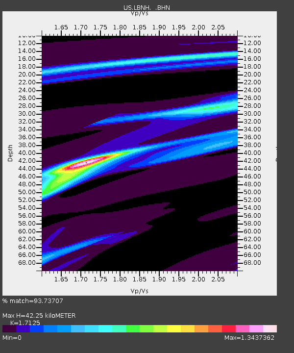
LBNH Lisbon, New Hampshire, USA - Earthquake Result Viewer

Earthquake location: Near Coast Of Jalisco, Mexico
Earthquake latitude/longitude: 18.8/-104.1
Earthquake time(UTC): 2003/01/22 (022) 02:06:34 GMT
Earthquake Depth: 24 km
Earthquake Magnitude: 6.5 MB, 7.6 MS, 7.6 MW, 7.4 MW
Earthquake Catalog/Contributor: WHDF/NEIC
Network: US United States National Seismic Network
Station: LBNH Lisbon, New Hampshire, USA
Lat/Lon: 44.24 N/71.93 W
Elevation: 367 m
Distance: 37.0 deg
Az: 39.511 deg
Baz: 237.001 deg
Ray Param: 0.07634585
Estimated Moho Depth: 42.25 km
Estimated Crust Vp/Vs: 1.71
Assumed Crust Vp: 6.419 km/s
Estimated Crust Vs: 3.748 km/s
Estimated Crust Poisson's Ratio: 0.24
Radial Match: 93.73707 %
Radial Bump: 105
Transverse Match: 74.558815 %
Transverse Bump: 400
SOD ConfigId: 110177
Insert Time: 2010-03-05 06:00:29.896 +0000
GWidth: 2.5
Max Bumps: 400
Tol: 0.001

Signal To Noise

ChannelStoNSTALTA
US:LBNH: :BHN:20030122T02:13:11.388015Z1.53190421.4164157E-69.246111E-7
US:LBNH: :BHE:20030122T02:13:11.388015Z3.45043133.3453277E-69.695391E-7
US:LBNH: :BHZ:20030122T02:13:11.388015Z3.69687775.179209E-61.4009685E-6
Arrivals
Ps5.1 SECOND
PpPs17 SECOND
PsPs/PpSs22 SECOND