You are here: Home > Network List > AT - Alaska Tsunami Warning Seismic System Stations List
> Station CRAG Craig, Alaska > Earthquake Result Viewer
CRAG Craig, Alaska - Earthquake Result Viewer
| Earthquake location: |
Southeast Of Loyalty Islands |
| Earthquake latitude/longitude: |
-22.5/173.1 |
| Earthquake time(UTC): |
2016/08/12 (225) 01:26:35 GMT |
| Earthquake Depth: |
10 km |
| Earthquake Magnitude: |
7.2 MWW, 7.6 MI |
| Earthquake Catalog/Contributor: |
NEIC PDE/NEIC COMCAT |
|
| Network: |
AT Alaska Tsunami Warning Seismic System |
| Station: |
CRAG Craig, Alaska |
| Lat/Lon: |
55.47 N/133.12 W |
| Elevation: |
58 m |
|
| Distance: |
90.1 deg |
| Az: |
27.343 deg |
| Baz: |
228.242 deg |
| Ray Param: |
0.04169875 |
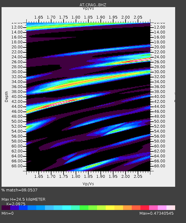
| Estimated Moho Depth: |
24.5 km |
| Estimated Crust Vp/Vs: |
2.10 |
| Assumed Crust Vp: |
6.472 km/s |
| Estimated Crust Vs: |
3.086 km/s |
| Estimated Crust Poisson's Ratio: |
0.35 |
|
| Radial Match: |
89.0537 % |
| Radial Bump: |
395 |
| Transverse Match: |
77.144455 % |
| Transverse Bump: |
400 |
| SOD ConfigId: |
11737051 |
| Insert Time: |
2019-04-25 06:04:49.613 +0000 |
| GWidth: |
2.5 |
| Max Bumps: |
400 |
| Tol: |
0.001 |
|

Signal To Noise
| Channel | StoN | STA | LTA |
| AT:CRAG: :BHZ:20160812T01:39:03.580002Z | 3.5332632 | 6.859102E-7 | 1.9412938E-7 |
| AT:CRAG: :BHN:20160812T01:39:03.580002Z | 0.9730997 | 2.0876051E-7 | 2.1453145E-7 |
| AT:CRAG: :BHE:20160812T01:39:03.580002Z | 1.4893847 | 4.3573104E-7 | 2.9255776E-7 |
| Arrivals |
| Ps | 4.2 SECOND |
| PpPs | 12 SECOND |
| PsPs/PpSs | 16 SECOND |


