You are here: Home > Network List > AU - Australian Seismological Centre Stations List
> Station MTN Manton Dam, Northern Territory > Earthquake Result Viewer
MTN Manton Dam, Northern Territory - Earthquake Result Viewer
| Earthquake location: |
Southeast Of Loyalty Islands |
| Earthquake latitude/longitude: |
-22.5/173.1 |
| Earthquake time(UTC): |
2016/08/12 (225) 01:26:35 GMT |
| Earthquake Depth: |
10 km |
| Earthquake Magnitude: |
7.2 MWW, 7.6 MI |
| Earthquake Catalog/Contributor: |
NEIC PDE/NEIC COMCAT |
|
| Network: |
AU Australian Seismological Centre |
| Station: |
MTN Manton Dam, Northern Territory |
| Lat/Lon: |
12.84 S/131.13 E |
| Elevation: |
137 m |
|
| Distance: |
41.0 deg |
| Az: |
276.259 deg |
| Baz: |
109.51 deg |
| Ray Param: |
0.07405646 |
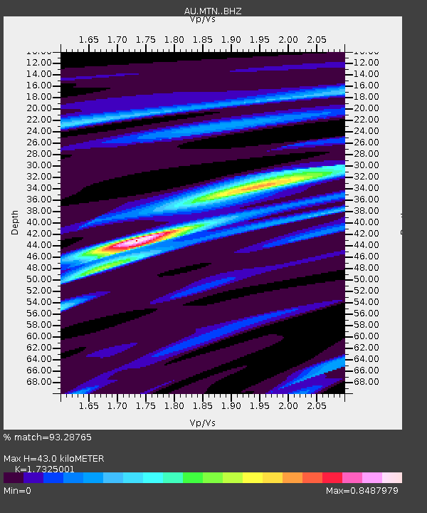
| Estimated Moho Depth: |
43.0 km |
| Estimated Crust Vp/Vs: |
1.73 |
| Assumed Crust Vp: |
6.61 km/s |
| Estimated Crust Vs: |
3.815 km/s |
| Estimated Crust Poisson's Ratio: |
0.25 |
|
| Radial Match: |
93.28765 % |
| Radial Bump: |
191 |
| Transverse Match: |
71.89616 % |
| Transverse Bump: |
400 |
| SOD ConfigId: |
11737051 |
| Insert Time: |
2019-04-25 06:05:00.979 +0000 |
| GWidth: |
2.5 |
| Max Bumps: |
400 |
| Tol: |
0.001 |
|

Signal To Noise
| Channel | StoN | STA | LTA |
| AU:MTN: :BHZ:20160812T01:33:47.643998Z | 27.537031 | 5.2331716E-6 | 1.9004123E-7 |
| AU:MTN: :BHN:20160812T01:33:47.643998Z | 12.315689 | 1.3955148E-6 | 1.13311955E-7 |
| AU:MTN: :BHE:20160812T01:33:47.643998Z | 26.218128 | 3.7885598E-6 | 1.4450154E-7 |
| Arrivals |
| Ps | 5.1 SECOND |
| PpPs | 16 SECOND |
| PsPs/PpSs | 22 SECOND |


