You are here: Home > Network List > AV - Alaska Volcano Observatory Stations List
> Station AKLV Akutan Long Valley, Akutan Volcano, Alaska > Earthquake Result Viewer
AKLV Akutan Long Valley, Akutan Volcano, Alaska - Earthquake Result Viewer
| Earthquake location: |
Southeast Of Loyalty Islands |
| Earthquake latitude/longitude: |
-22.5/173.1 |
| Earthquake time(UTC): |
2016/08/12 (225) 01:26:35 GMT |
| Earthquake Depth: |
10 km |
| Earthquake Magnitude: |
7.2 MWW, 7.6 MI |
| Earthquake Catalog/Contributor: |
NEIC PDE/NEIC COMCAT |
|
| Network: |
AV Alaska Volcano Observatory |
| Station: |
AKLV Akutan Long Valley, Akutan Volcano, Alaska |
| Lat/Lon: |
54.16 N/165.96 W |
| Elevation: |
551 m |
|
| Distance: |
78.4 deg |
| Az: |
12.382 deg |
| Baz: |
199.707 deg |
| Ray Param: |
0.04963624 |
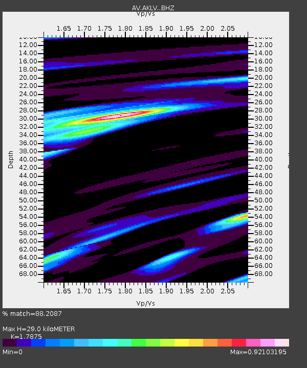
| Estimated Moho Depth: |
29.0 km |
| Estimated Crust Vp/Vs: |
1.79 |
| Assumed Crust Vp: |
5.989 km/s |
| Estimated Crust Vs: |
3.351 km/s |
| Estimated Crust Poisson's Ratio: |
0.27 |
|
| Radial Match: |
88.2087 % |
| Radial Bump: |
400 |
| Transverse Match: |
78.91639 % |
| Transverse Bump: |
400 |
| SOD ConfigId: |
11737051 |
| Insert Time: |
2019-04-25 06:05:09.111 +0000 |
| GWidth: |
2.5 |
| Max Bumps: |
400 |
| Tol: |
0.001 |
|
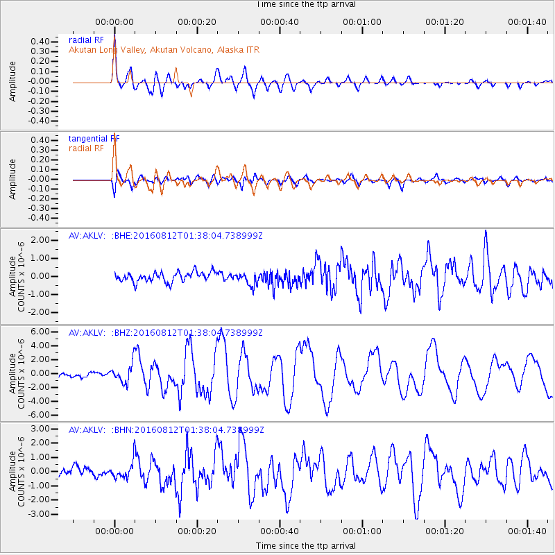
Signal To Noise
| Channel | StoN | STA | LTA |
| AV:AKLV: :BHZ:20160812T01:38:04.738999Z | 4.7314744 | 1.5368131E-6 | 3.248064E-7 |
| AV:AKLV: :BHN:20160812T01:38:04.738999Z | 2.5396733 | 6.545856E-7 | 2.5774403E-7 |
| AV:AKLV: :BHE:20160812T01:38:04.738999Z | 1.3764167 | 3.6713067E-7 | 2.6672933E-7 |
| Arrivals |
| Ps | 3.9 SECOND |
| PpPs | 13 SECOND |
| PsPs/PpSs | 17 SECOND |


