You are here: Home > Network List > AV - Alaska Volcano Observatory Stations List
> Station CLCO Concord Point, Cleveland Volcano, Alaska > Earthquake Result Viewer
CLCO Concord Point, Cleveland Volcano, Alaska - Earthquake Result Viewer
| Earthquake location: |
Southeast Of Loyalty Islands |
| Earthquake latitude/longitude: |
-22.5/173.1 |
| Earthquake time(UTC): |
2016/08/12 (225) 01:26:35 GMT |
| Earthquake Depth: |
10 km |
| Earthquake Magnitude: |
7.2 MWW, 7.6 MI |
| Earthquake Catalog/Contributor: |
NEIC PDE/NEIC COMCAT |
|
| Network: |
AV Alaska Volcano Observatory |
| Station: |
CLCO Concord Point, Cleveland Volcano, Alaska |
| Lat/Lon: |
52.79 N/169.72 W |
| Elevation: |
137 m |
|
| Distance: |
76.4 deg |
| Az: |
10.626 deg |
| Baz: |
196.306 deg |
| Ray Param: |
0.05099284 |
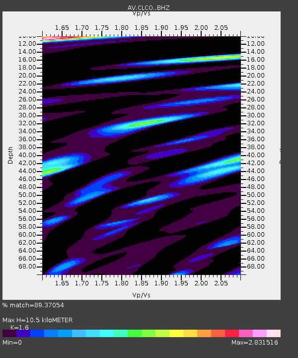
| Estimated Moho Depth: |
10.5 km |
| Estimated Crust Vp/Vs: |
1.60 |
| Assumed Crust Vp: |
5.88 km/s |
| Estimated Crust Vs: |
3.675 km/s |
| Estimated Crust Poisson's Ratio: |
0.18 |
|
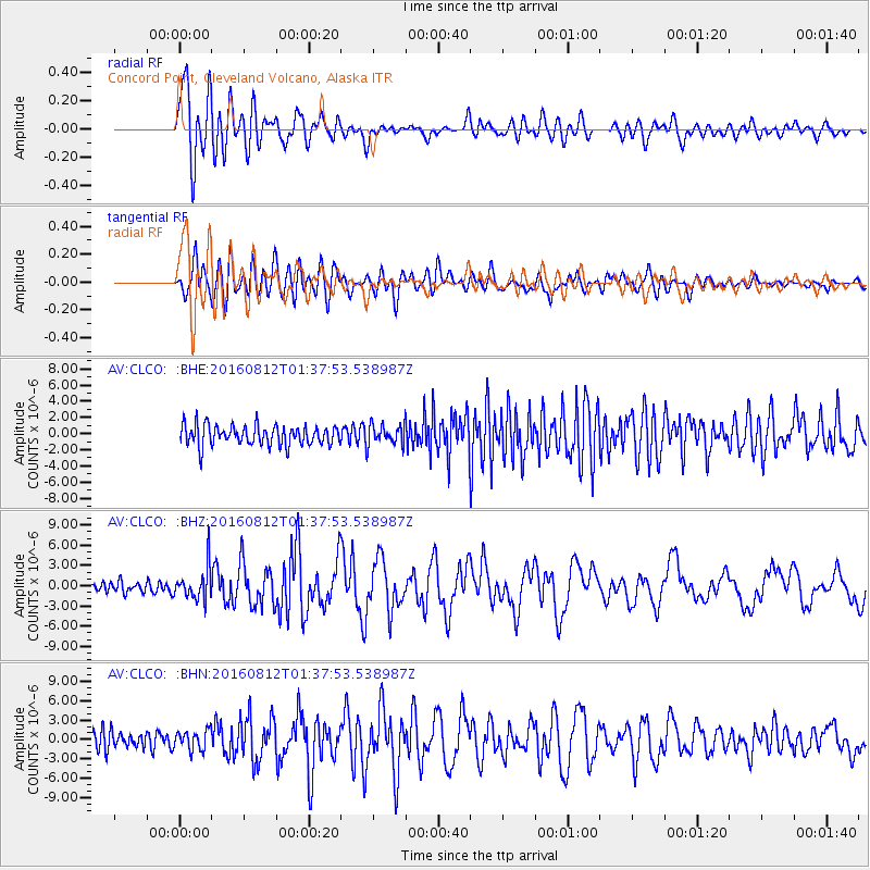
| Radial Match: |
89.37054 % |
| Radial Bump: |
400 |
| Transverse Match: |
81.715126 % |
| Transverse Bump: |
400 |
| SOD ConfigId: |
11737051 |
| Insert Time: |
2019-04-25 06:05:19.787 +0000 |
| GWidth: |
2.5 |
| Max Bumps: |
400 |
| Tol: |
0.001 |
|
Signal To Noise
| Channel | StoN | STA | LTA |
| AV:CLCO: :BHZ:20160812T01:37:53.538987Z | 3.5086982 | 2.4774329E-6 | 7.060832E-7 |
| AV:CLCO: :BHN:20160812T01:37:53.538987Z | 1.3443553 | 1.5268282E-6 | 1.1357325E-6 |
| AV:CLCO: :BHE:20160812T01:37:53.538987Z | 1.0407844 | 1.2935757E-6 | 1.2428854E-6 |
| Arrivals |
| Ps | 1.1 SECOND |
| PpPs | 4.5 SECOND |
| PsPs/PpSs | 5.6 SECOND |


