You are here: Home > Network List > AV - Alaska Volcano Observatory Stations List
> Station SPCR Ckakachatna River, Mount Spurr, Alaska > Earthquake Result Viewer
SPCR Ckakachatna River, Mount Spurr, Alaska - Earthquake Result Viewer
| Earthquake location: |
Southeast Of Loyalty Islands |
| Earthquake latitude/longitude: |
-22.5/173.1 |
| Earthquake time(UTC): |
2016/08/12 (225) 01:26:35 GMT |
| Earthquake Depth: |
10 km |
| Earthquake Magnitude: |
7.2 MWW, 7.6 MI |
| Earthquake Catalog/Contributor: |
NEIC PDE/NEIC COMCAT |
|
| Network: |
AV Alaska Volcano Observatory |
| Station: |
SPCR Ckakachatna River, Mount Spurr, Alaska |
| Lat/Lon: |
61.20 N/152.21 W |
| Elevation: |
984 m |
|
| Distance: |
88.0 deg |
| Az: |
16.004 deg |
| Baz: |
211.772 deg |
| Ray Param: |
0.042934775 |
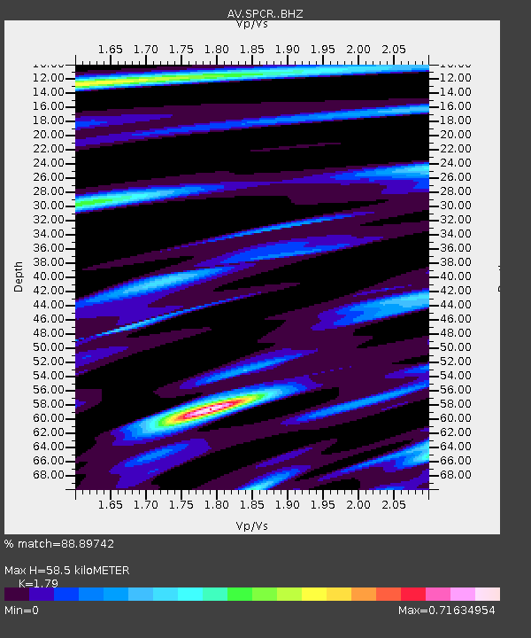
| Estimated Moho Depth: |
58.5 km |
| Estimated Crust Vp/Vs: |
1.79 |
| Assumed Crust Vp: |
6.566 km/s |
| Estimated Crust Vs: |
3.668 km/s |
| Estimated Crust Poisson's Ratio: |
0.27 |
|
| Radial Match: |
88.89742 % |
| Radial Bump: |
400 |
| Transverse Match: |
86.081436 % |
| Transverse Bump: |
400 |
| SOD ConfigId: |
11737051 |
| Insert Time: |
2019-04-25 06:05:39.945 +0000 |
| GWidth: |
2.5 |
| Max Bumps: |
400 |
| Tol: |
0.001 |
|

Signal To Noise
| Channel | StoN | STA | LTA |
| AV:SPCR: :BHZ:20160812T01:38:53.679001Z | 5.5614038 | 8.5154386E-7 | 1.5311672E-7 |
| AV:SPCR: :BHN:20160812T01:38:53.679001Z | 2.3537664 | 2.573201E-7 | 1.093227E-7 |
| AV:SPCR: :BHE:20160812T01:38:53.679001Z | 1.2693658 | 2.4543863E-7 | 1.933553E-7 |
| Arrivals |
| Ps | 7.2 SECOND |
| PpPs | 24 SECOND |
| PsPs/PpSs | 31 SECOND |


