You are here: Home > Network List > AZ - ANZA Regional Network Stations List
> Station MONP2 Monument Peak TA Vault, Anza, CA, USA > Earthquake Result Viewer
MONP2 Monument Peak TA Vault, Anza, CA, USA - Earthquake Result Viewer
| Earthquake location: |
Southeast Of Loyalty Islands |
| Earthquake latitude/longitude: |
-22.5/173.1 |
| Earthquake time(UTC): |
2016/08/12 (225) 01:26:35 GMT |
| Earthquake Depth: |
10 km |
| Earthquake Magnitude: |
7.2 MWW, 7.6 MI |
| Earthquake Catalog/Contributor: |
NEIC PDE/NEIC COMCAT |
|
| Network: |
AZ ANZA Regional Network |
| Station: |
MONP2 Monument Peak TA Vault, Anza, CA, USA |
| Lat/Lon: |
32.89 N/116.42 W |
| Elevation: |
1000 m |
|
| Distance: |
86.9 deg |
| Az: |
52.571 deg |
| Baz: |
240.796 deg |
| Ray Param: |
0.04373458 |
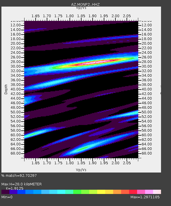
| Estimated Moho Depth: |
28.0 km |
| Estimated Crust Vp/Vs: |
1.91 |
| Assumed Crust Vp: |
6.264 km/s |
| Estimated Crust Vs: |
3.275 km/s |
| Estimated Crust Poisson's Ratio: |
0.31 |
|
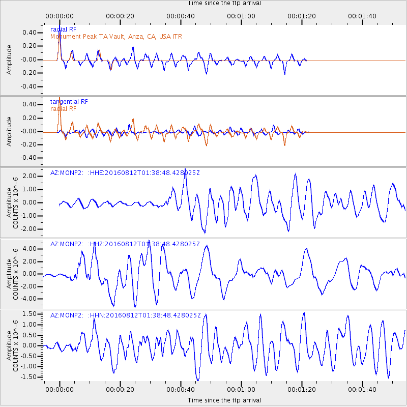
| Radial Match: |
92.70297 % |
| Radial Bump: |
358 |
| Transverse Match: |
83.54723 % |
| Transverse Bump: |
400 |
| SOD ConfigId: |
11737051 |
| Insert Time: |
2019-04-25 06:05:46.514 +0000 |
| GWidth: |
2.5 |
| Max Bumps: |
400 |
| Tol: |
0.001 |
|
Signal To Noise
| Channel | StoN | STA | LTA |
| AZ:MONP2: :HHZ:20160812T01:38:48.428025Z | 3.1738722 | 3.9531665E-7 | 1.2455342E-7 |
| AZ:MONP2: :HHN:20160812T01:38:48.428025Z | 1.2066312 | 1.3117929E-7 | 1.0871532E-7 |
| AZ:MONP2: :HHE:20160812T01:38:48.428025Z | 0.8383753 | 1.4484412E-7 | 1.7276764E-7 |
| Arrivals |
| Ps | 4.2 SECOND |
| PpPs | 13 SECOND |
| PsPs/PpSs | 17 SECOND |


