You are here: Home > Network List > AZ - ANZA Regional Network Stations List
> Station SMER AZ.SMER > Earthquake Result Viewer
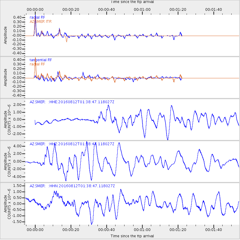
SMER AZ.SMER - Earthquake Result Viewer
*The percent match for this event was below the threshold and hence no stack was calculated.
| Earthquake location: |
Southeast Of Loyalty Islands |
| Earthquake latitude/longitude: |
-22.5/173.1 |
| Earthquake time(UTC): |
2016/08/12 (225) 01:26:35 GMT |
| Earthquake Depth: |
10 km |
| Earthquake Magnitude: |
7.2 MWW, 7.6 MI |
| Earthquake Catalog/Contributor: |
NEIC PDE/NEIC COMCAT |
|
| Network: |
AZ ANZA Regional Network |
| Station: |
SMER AZ.SMER |
| Lat/Lon: |
33.46 N/117.17 W |
| Elevation: |
355 m |
|
| Distance: |
86.6 deg |
| Az: |
51.77 deg |
| Baz: |
240.343 deg |
| Ray Param: |
$rayparam |
*The percent match for this event was below the threshold and hence was not used in the summary stack. |
|
| Radial Match: |
75.9233 % |
| Radial Bump: |
269 |
| Transverse Match: |
56.088966 % |
| Transverse Bump: |
272 |
| SOD ConfigId: |
11737051 |
| Insert Time: |
2019-04-25 06:05:49.889 +0000 |
| GWidth: |
2.5 |
| Max Bumps: |
400 |
| Tol: |
0.001 |
|
Signal To Noise
| Channel | StoN | STA | LTA |
| AZ:SMER: :HHZ:20160812T01:38:47.118027Z | 4.888897 | 3.6015422E-7 | 7.3667785E-8 |
| AZ:SMER: :HHN:20160812T01:38:47.118027Z | 0.7047558 | 5.6730374E-7 | 8.04965E-7 |
| AZ:SMER: :HHE:20160812T01:38:47.118027Z | 0.5115918 | 1.255411E-7 | 2.4539312E-7 |
| Arrivals |
| Ps | |
| PpPs | |
| PsPs/PpSs | |


