You are here: Home > Network List > CI - Caltech Regional Seismic Network Stations List
> Station BC3 Big Chuckawalla Mtns, Desert Center, CA, USA > Earthquake Result Viewer
BC3 Big Chuckawalla Mtns, Desert Center, CA, USA - Earthquake Result Viewer
| Earthquake location: |
Southeast Of Loyalty Islands |
| Earthquake latitude/longitude: |
-22.5/173.1 |
| Earthquake time(UTC): |
2016/08/12 (225) 01:26:35 GMT |
| Earthquake Depth: |
10 km |
| Earthquake Magnitude: |
7.2 MWW, 7.6 MI |
| Earthquake Catalog/Contributor: |
NEIC PDE/NEIC COMCAT |
|
| Network: |
CI Caltech Regional Seismic Network |
| Station: |
BC3 Big Chuckawalla Mtns, Desert Center, CA, USA |
| Lat/Lon: |
33.66 N/115.45 W |
| Elevation: |
1137 m |
|
| Distance: |
88.0 deg |
| Az: |
52.298 deg |
| Baz: |
241.312 deg |
| Ray Param: |
0.042948492 |
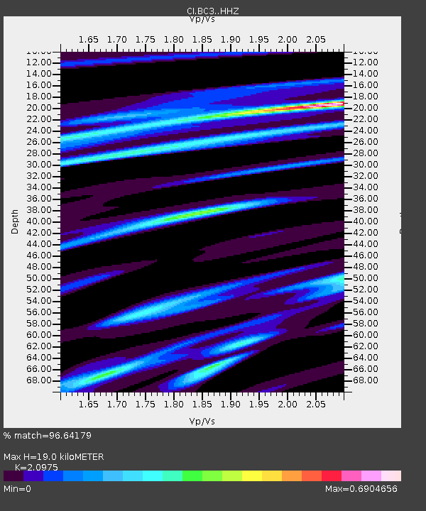
| Estimated Moho Depth: |
19.0 km |
| Estimated Crust Vp/Vs: |
2.10 |
| Assumed Crust Vp: |
6.155 km/s |
| Estimated Crust Vs: |
2.934 km/s |
| Estimated Crust Poisson's Ratio: |
0.35 |
|
| Radial Match: |
96.64179 % |
| Radial Bump: |
231 |
| Transverse Match: |
86.59058 % |
| Transverse Bump: |
400 |
| SOD ConfigId: |
11737051 |
| Insert Time: |
2019-04-25 06:06:44.528 +0000 |
| GWidth: |
2.5 |
| Max Bumps: |
400 |
| Tol: |
0.001 |
|
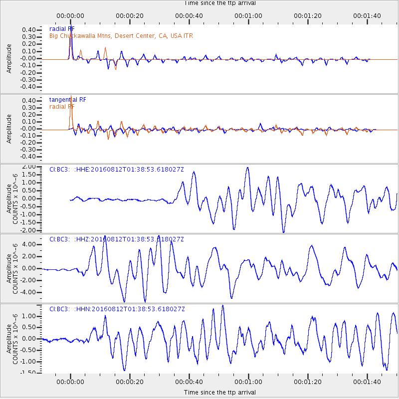
Signal To Noise
| Channel | StoN | STA | LTA |
| CI:BC3: :HHZ:20160812T01:38:53.618027Z | 5.561576 | 4.1656315E-7 | 7.49002E-8 |
| CI:BC3: :HHN:20160812T01:38:53.618027Z | 0.6226511 | 7.2637E-8 | 1.16657624E-7 |
| CI:BC3: :HHE:20160812T01:38:53.618027Z | 2.2220883 | 1.4104654E-7 | 6.3474765E-8 |
| Arrivals |
| Ps | 3.4 SECOND |
| PpPs | 9.4 SECOND |
| PsPs/PpSs | 13 SECOND |


