You are here: Home > Network List > CI - Caltech Regional Seismic Network Stations List
> Station PLM Palomar, Palomar Mountain, CA, USA > Earthquake Result Viewer
PLM Palomar, Palomar Mountain, CA, USA - Earthquake Result Viewer
| Earthquake location: |
Southeast Of Loyalty Islands |
| Earthquake latitude/longitude: |
-22.5/173.1 |
| Earthquake time(UTC): |
2016/08/12 (225) 01:26:35 GMT |
| Earthquake Depth: |
10 km |
| Earthquake Magnitude: |
7.2 MWW, 7.6 MI |
| Earthquake Catalog/Contributor: |
NEIC PDE/NEIC COMCAT |
|
| Network: |
CI Caltech Regional Seismic Network |
| Station: |
PLM Palomar, Palomar Mountain, CA, USA |
| Lat/Lon: |
33.35 N/116.86 W |
| Elevation: |
1691 m |
|
| Distance: |
86.8 deg |
| Az: |
51.988 deg |
| Baz: |
240.524 deg |
| Ray Param: |
0.043805353 |
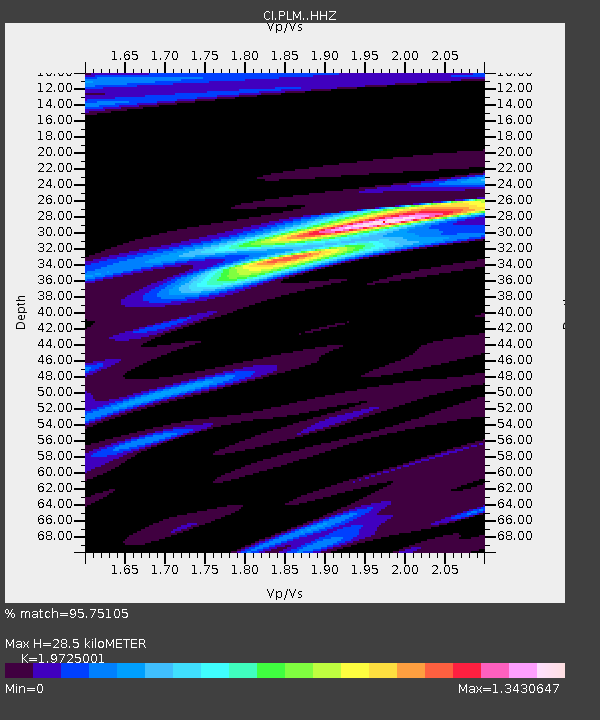
| Estimated Moho Depth: |
28.5 km |
| Estimated Crust Vp/Vs: |
1.97 |
| Assumed Crust Vp: |
6.264 km/s |
| Estimated Crust Vs: |
3.175 km/s |
| Estimated Crust Poisson's Ratio: |
0.33 |
|
| Radial Match: |
95.75105 % |
| Radial Bump: |
375 |
| Transverse Match: |
90.019585 % |
| Transverse Bump: |
400 |
| SOD ConfigId: |
11737051 |
| Insert Time: |
2019-04-25 06:07:10.982 +0000 |
| GWidth: |
2.5 |
| Max Bumps: |
400 |
| Tol: |
0.001 |
|

Signal To Noise
| Channel | StoN | STA | LTA |
| CI:PLM: :HHZ:20160812T01:38:47.957993Z | 2.7587512 | 4.0964667E-7 | 1.484899E-7 |
| CI:PLM: :HHN:20160812T01:38:47.957993Z | 0.96440375 | 1.2170082E-7 | 1.2619282E-7 |
| CI:PLM: :HHE:20160812T01:38:47.957993Z | 0.98030305 | 1.8170167E-7 | 1.8535255E-7 |
| Arrivals |
| Ps | 4.5 SECOND |
| PpPs | 13 SECOND |
| PsPs/PpSs | 18 SECOND |


