You are here: Home > Network List > CI - Caltech Regional Seismic Network Stations List
> Station TUQ Turquiose Mountain, Baker, CA, USA > Earthquake Result Viewer
TUQ Turquiose Mountain, Baker, CA, USA - Earthquake Result Viewer
| Earthquake location: |
Southeast Of Loyalty Islands |
| Earthquake latitude/longitude: |
-22.5/173.1 |
| Earthquake time(UTC): |
2016/08/12 (225) 01:26:35 GMT |
| Earthquake Depth: |
10 km |
| Earthquake Magnitude: |
7.2 MWW, 7.6 MI |
| Earthquake Catalog/Contributor: |
NEIC PDE/NEIC COMCAT |
|
| Network: |
CI Caltech Regional Seismic Network |
| Station: |
TUQ Turquiose Mountain, Baker, CA, USA |
| Lat/Lon: |
35.44 N/115.92 W |
| Elevation: |
1350 m |
|
| Distance: |
88.5 deg |
| Az: |
50.554 deg |
| Baz: |
240.993 deg |
| Ray Param: |
0.04256409 |
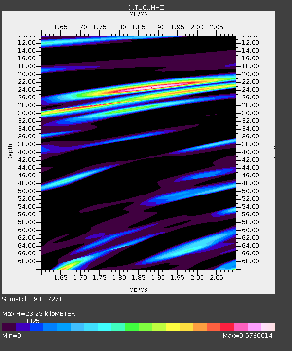
| Estimated Moho Depth: |
23.25 km |
| Estimated Crust Vp/Vs: |
1.88 |
| Assumed Crust Vp: |
6.276 km/s |
| Estimated Crust Vs: |
3.334 km/s |
| Estimated Crust Poisson's Ratio: |
0.30 |
|
| Radial Match: |
93.17271 % |
| Radial Bump: |
400 |
| Transverse Match: |
86.39754 % |
| Transverse Bump: |
400 |
| SOD ConfigId: |
11737051 |
| Insert Time: |
2019-04-25 06:07:21.889 +0000 |
| GWidth: |
2.5 |
| Max Bumps: |
400 |
| Tol: |
0.001 |
|
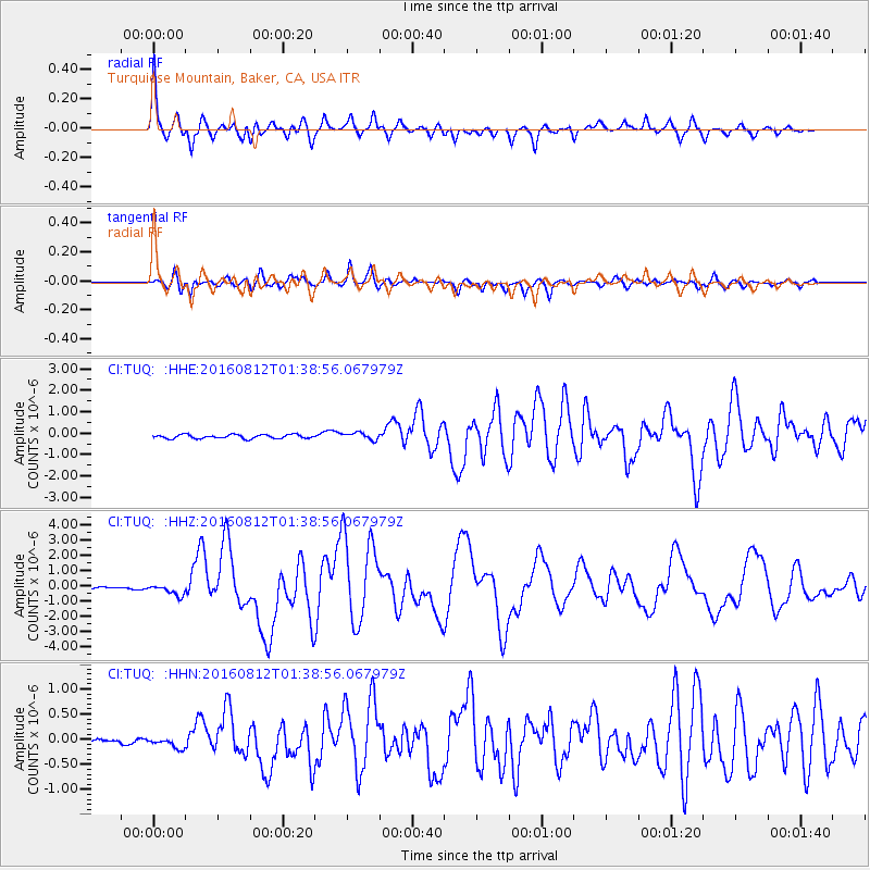
Signal To Noise
| Channel | StoN | STA | LTA |
| CI:TUQ: :HHZ:20160812T01:38:56.067979Z | 3.900282 | 3.6758382E-7 | 9.424545E-8 |
| CI:TUQ: :HHN:20160812T01:38:56.067979Z | 1.1935962 | 1.0319913E-7 | 8.646067E-8 |
| CI:TUQ: :HHE:20160812T01:38:56.067979Z | 1.8537786 | 1.6852785E-7 | 9.091045E-8 |
| Arrivals |
| Ps | 3.3 SECOND |
| PpPs | 10 SECOND |
| PsPs/PpSs | 14 SECOND |


