You are here: Home > Network List > MB - Montana Regional Seismic Network Stations List
> Station LDM Little Jackson Creek seismic vault > Earthquake Result Viewer
LDM Little Jackson Creek seismic vault - Earthquake Result Viewer
| Earthquake location: |
Southeast Of Loyalty Islands |
| Earthquake latitude/longitude: |
-22.5/173.1 |
| Earthquake time(UTC): |
2016/08/12 (225) 01:26:35 GMT |
| Earthquake Depth: |
10 km |
| Earthquake Magnitude: |
7.2 MWW, 7.6 MI |
| Earthquake Catalog/Contributor: |
NEIC PDE/NEIC COMCAT |
|
| Network: |
MB Montana Regional Seismic Network |
| Station: |
LDM Little Jackson Creek seismic vault |
| Lat/Lon: |
48.45 N/115.32 W |
| Elevation: |
840 m |
|
| Distance: |
95.1 deg |
| Az: |
39.353 deg |
| Baz: |
241.75 deg |
| Ray Param: |
0.040867046 |
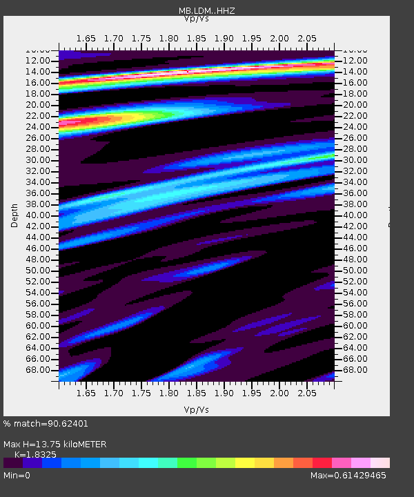
| Estimated Moho Depth: |
13.75 km |
| Estimated Crust Vp/Vs: |
1.83 |
| Assumed Crust Vp: |
6.622 km/s |
| Estimated Crust Vs: |
3.614 km/s |
| Estimated Crust Poisson's Ratio: |
0.29 |
|
| Radial Match: |
90.62401 % |
| Radial Bump: |
400 |
| Transverse Match: |
90.96095 % |
| Transverse Bump: |
400 |
| SOD ConfigId: |
11737051 |
| Insert Time: |
2019-04-25 06:08:38.281 +0000 |
| GWidth: |
2.5 |
| Max Bumps: |
400 |
| Tol: |
0.001 |
|

Signal To Noise
| Channel | StoN | STA | LTA |
| MB:LDM: :HHZ:20160812T01:39:26.720017Z | 3.7676742 | 1.0916992E-12 | 2.8975417E-13 |
| MB:LDM: :HHN:20160812T01:39:26.720017Z | 1.4444022 | 2.664495E-13 | 1.8447043E-13 |
| MB:LDM: :HHE:20160812T01:39:26.720017Z | 1.7652559 | 3.2826929E-13 | 1.859613E-13 |
| Arrivals |
| Ps | 1.8 SECOND |
| PpPs | 5.8 SECOND |
| PsPs/PpSs | 7.5 SECOND |


