You are here: Home > Network List > NN - Western Great Basin/Eastern Sierra Nevada Stations List
> Station CTC N. Tahoe City Carnelian Bay > Earthquake Result Viewer
CTC N. Tahoe City Carnelian Bay - Earthquake Result Viewer
| Earthquake location: |
Southeast Of Loyalty Islands |
| Earthquake latitude/longitude: |
-22.5/173.1 |
| Earthquake time(UTC): |
2016/08/12 (225) 01:26:35 GMT |
| Earthquake Depth: |
10 km |
| Earthquake Magnitude: |
7.2 MWW, 7.6 MI |
| Earthquake Catalog/Contributor: |
NEIC PDE/NEIC COMCAT |
|
| Network: |
NN Western Great Basin/Eastern Sierra Nevada |
| Station: |
CTC N. Tahoe City Carnelian Bay |
| Lat/Lon: |
39.21 N/120.13 W |
| Elevation: |
2147 m |
|
| Distance: |
87.5 deg |
| Az: |
45.61 deg |
| Baz: |
238.279 deg |
| Ray Param: |
0.043296568 |
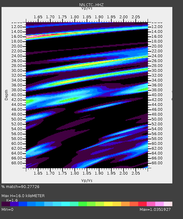
| Estimated Moho Depth: |
16.0 km |
| Estimated Crust Vp/Vs: |
1.60 |
| Assumed Crust Vp: |
6.597 km/s |
| Estimated Crust Vs: |
4.123 km/s |
| Estimated Crust Poisson's Ratio: |
0.18 |
|
| Radial Match: |
90.27726 % |
| Radial Bump: |
400 |
| Transverse Match: |
82.06988 % |
| Transverse Bump: |
400 |
| SOD ConfigId: |
11737051 |
| Insert Time: |
2019-04-25 06:08:51.178 +0000 |
| GWidth: |
2.5 |
| Max Bumps: |
400 |
| Tol: |
0.001 |
|

Signal To Noise
| Channel | StoN | STA | LTA |
| NN:CTC: :HHZ:20160812T01:38:51.348008Z | 4.5454617 | 4.5205832E-7 | 9.945268E-8 |
| NN:CTC: :HHN:20160812T01:38:51.348008Z | 1.4674404 | 1.3005435E-7 | 8.862666E-8 |
| NN:CTC: :HHE:20160812T01:38:51.348008Z | 2.0645697 | 1.8052059E-7 | 8.743739E-8 |
| Arrivals |
| Ps | 1.5 SECOND |
| PpPs | 6.1 SECOND |
| PsPs/PpSs | 7.6 SECOND |


