You are here: Home > Network List > NN - Western Great Basin/Eastern Sierra Nevada Stations List
> Station MZPB Montezuma,NV,USA analog reactivation > Earthquake Result Viewer
MZPB Montezuma,NV,USA analog reactivation - Earthquake Result Viewer
| Earthquake location: |
Southeast Of Loyalty Islands |
| Earthquake latitude/longitude: |
-22.5/173.1 |
| Earthquake time(UTC): |
2016/08/12 (225) 01:26:35 GMT |
| Earthquake Depth: |
10 km |
| Earthquake Magnitude: |
7.2 MWW, 7.6 MI |
| Earthquake Catalog/Contributor: |
NEIC PDE/NEIC COMCAT |
|
| Network: |
NN Western Great Basin/Eastern Sierra Nevada |
| Station: |
MZPB Montezuma,NV,USA analog reactivation |
| Lat/Lon: |
37.70 N/117.38 W |
| Elevation: |
2371 m |
|
| Distance: |
88.6 deg |
| Az: |
48.007 deg |
| Baz: |
240.06 deg |
| Ray Param: |
0.042498 |
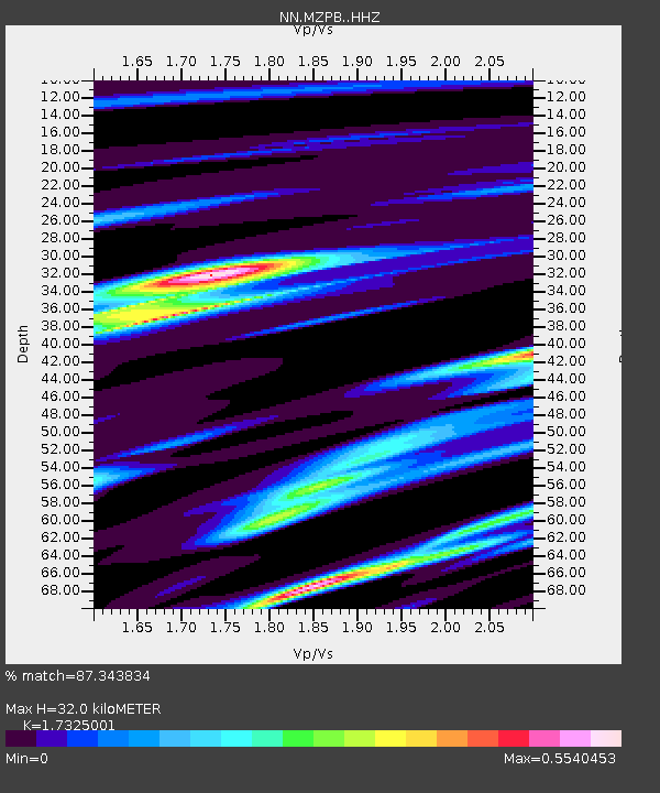
| Estimated Moho Depth: |
32.0 km |
| Estimated Crust Vp/Vs: |
1.73 |
| Assumed Crust Vp: |
6.279 km/s |
| Estimated Crust Vs: |
3.624 km/s |
| Estimated Crust Poisson's Ratio: |
0.25 |
|
| Radial Match: |
87.343834 % |
| Radial Bump: |
397 |
| Transverse Match: |
56.90603 % |
| Transverse Bump: |
400 |
| SOD ConfigId: |
11737051 |
| Insert Time: |
2019-04-25 06:08:59.247 +0000 |
| GWidth: |
2.5 |
| Max Bumps: |
400 |
| Tol: |
0.001 |
|

Signal To Noise
| Channel | StoN | STA | LTA |
| NN:MZPB: :HHZ:20160812T01:38:56.484971Z | 7.0066285 | 1.9614673E-7 | 2.7994451E-8 |
| NN:MZPB: :HHN:20160812T01:38:56.484971Z | 1.0706518 | 6.173726E-8 | 5.766325E-8 |
| NN:MZPB: :HHE:20160812T01:38:56.484971Z | 0.43488756 | 7.876067E-8 | 1.8110582E-7 |
| Arrivals |
| Ps | 3.8 SECOND |
| PpPs | 14 SECOND |
| PsPs/PpSs | 17 SECOND |


