You are here: Home > Network List > TA - USArray Transportable Network (new EarthScope stations) Stations List
> Station G21K Allakaket, AK, USA > Earthquake Result Viewer
G21K Allakaket, AK, USA - Earthquake Result Viewer
| Earthquake location: |
Southeast Of Loyalty Islands |
| Earthquake latitude/longitude: |
-22.5/173.1 |
| Earthquake time(UTC): |
2016/08/12 (225) 01:26:35 GMT |
| Earthquake Depth: |
10 km |
| Earthquake Magnitude: |
7.2 MWW, 7.6 MI |
| Earthquake Catalog/Contributor: |
NEIC PDE/NEIC COMCAT |
|
| Network: |
TA USArray Transportable Network (new EarthScope stations) |
| Station: |
G21K Allakaket, AK, USA |
| Lat/Lon: |
66.52 N/153.51 W |
| Elevation: |
446 m |
|
| Distance: |
92.2 deg |
| Az: |
12.749 deg |
| Baz: |
210.614 deg |
| Ray Param: |
0.04148842 |
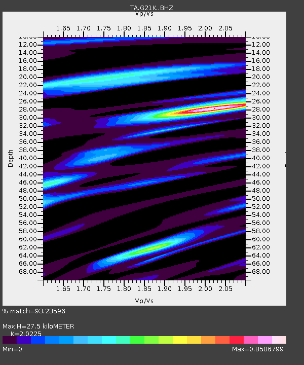
| Estimated Moho Depth: |
27.5 km |
| Estimated Crust Vp/Vs: |
2.02 |
| Assumed Crust Vp: |
6.455 km/s |
| Estimated Crust Vs: |
3.192 km/s |
| Estimated Crust Poisson's Ratio: |
0.34 |
|
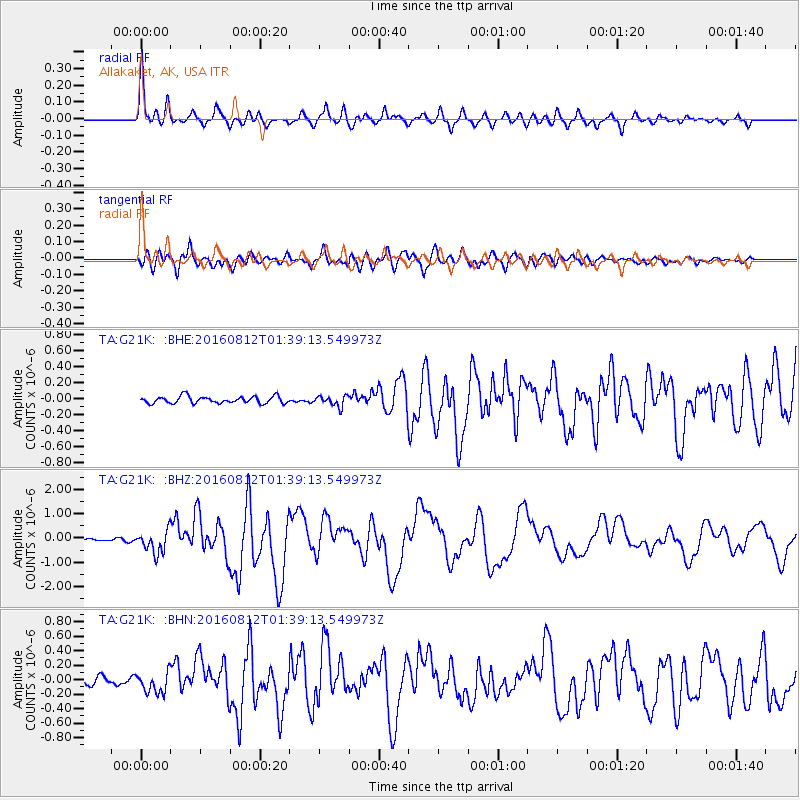
| Radial Match: |
93.23596 % |
| Radial Bump: |
358 |
| Transverse Match: |
86.06366 % |
| Transverse Bump: |
400 |
| SOD ConfigId: |
11737051 |
| Insert Time: |
2019-04-25 06:10:21.887 +0000 |
| GWidth: |
2.5 |
| Max Bumps: |
400 |
| Tol: |
0.001 |
|
Signal To Noise
| Channel | StoN | STA | LTA |
| TA:G21K: :BHZ:20160812T01:39:13.549973Z | 5.876028 | 4.5562643E-7 | 7.7539866E-8 |
| TA:G21K: :BHN:20160812T01:39:13.549973Z | 3.2032676 | 1.4781337E-7 | 4.6144557E-8 |
| TA:G21K: :BHE:20160812T01:39:13.549973Z | 1.5086076 | 6.386688E-8 | 4.233498E-8 |
| Arrivals |
| Ps | 4.4 SECOND |
| PpPs | 13 SECOND |
| PsPs/PpSs | 17 SECOND |


