You are here: Home > Network List > TA - USArray Transportable Network (new EarthScope stations) Stations List
> Station M27K Edge Creek, AK, USA > Earthquake Result Viewer
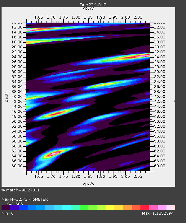
M27K Edge Creek, AK, USA - Earthquake Result Viewer
| Earthquake location: |
Southeast Of Loyalty Islands |
| Earthquake latitude/longitude: |
-22.5/173.1 |
| Earthquake time(UTC): |
2016/08/12 (225) 01:26:35 GMT |
| Earthquake Depth: |
10 km |
| Earthquake Magnitude: |
7.2 MWW, 7.6 MI |
| Earthquake Catalog/Contributor: |
NEIC PDE/NEIC COMCAT |
|
| Network: |
TA USArray Transportable Network (new EarthScope stations) |
| Station: |
M27K Edge Creek, AK, USA |
| Lat/Lon: |
62.36 N/141.88 W |
| Elevation: |
1536 m |
|
| Distance: |
91.8 deg |
| Az: |
19.27 deg |
| Baz: |
220.873 deg |
| Ray Param: |
0.0415535 |
| Estimated Moho Depth: |
12.75 km |
| Estimated Crust Vp/Vs: |
1.61 |
| Assumed Crust Vp: |
6.566 km/s |
| Estimated Crust Vs: |
4.091 km/s |
| Estimated Crust Poisson's Ratio: |
0.18 |
|
| Radial Match: |
90.27331 % |
| Radial Bump: |
400 |
| Transverse Match: |
85.60232 % |
| Transverse Bump: |
400 |
| SOD ConfigId: |
11737051 |
| Insert Time: |
2019-04-25 06:11:00.112 +0000 |
| GWidth: |
2.5 |
| Max Bumps: |
400 |
| Tol: |
0.001 |
|

Signal To Noise
| Channel | StoN | STA | LTA |
| TA:M27K: :BHZ:20160812T01:39:11.574998Z | 9.865536 | 6.690851E-7 | 6.782045E-8 |
| TA:M27K: :BHN:20160812T01:39:11.574998Z | 2.388786 | 1.700041E-7 | 7.116757E-8 |
| TA:M27K: :BHE:20160812T01:39:11.574998Z | 2.040538 | 1.4175194E-7 | 6.946792E-8 |
| Arrivals |
| Ps | 1.2 SECOND |
| PpPs | 4.9 SECOND |
| PsPs/PpSs | 6.1 SECOND |


