You are here: Home > Network List > TA - USArray Transportable Network (new EarthScope stations) Stations List
> Station TPFO Pinon Flats, CA, USA > Earthquake Result Viewer
TPFO Pinon Flats, CA, USA - Earthquake Result Viewer
| Earthquake location: |
Southeast Of Loyalty Islands |
| Earthquake latitude/longitude: |
-22.5/173.1 |
| Earthquake time(UTC): |
2016/08/12 (225) 01:26:35 GMT |
| Earthquake Depth: |
10 km |
| Earthquake Magnitude: |
7.2 MWW, 7.6 MI |
| Earthquake Catalog/Contributor: |
NEIC PDE/NEIC COMCAT |
|
| Network: |
TA USArray Transportable Network (new EarthScope stations) |
| Station: |
TPFO Pinon Flats, CA, USA |
| Lat/Lon: |
33.61 N/116.45 W |
| Elevation: |
1275 m |
|
| Distance: |
87.2 deg |
| Az: |
51.936 deg |
| Baz: |
240.745 deg |
| Ray Param: |
0.043496937 |
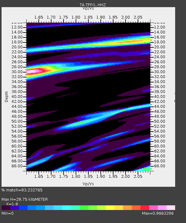
| Estimated Moho Depth: |
29.75 km |
| Estimated Crust Vp/Vs: |
1.60 |
| Assumed Crust Vp: |
6.264 km/s |
| Estimated Crust Vs: |
3.915 km/s |
| Estimated Crust Poisson's Ratio: |
0.18 |
|
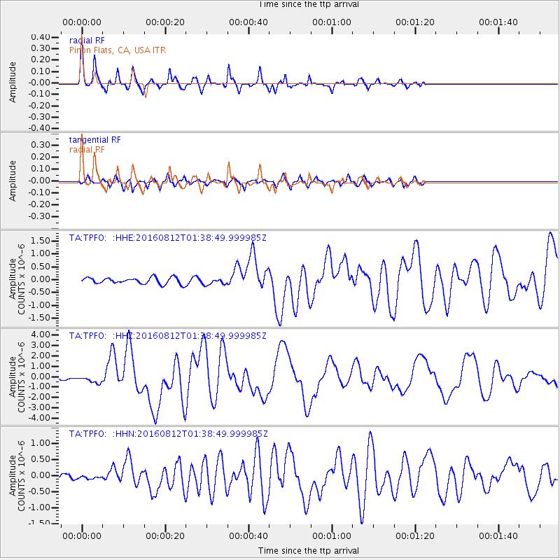
| Radial Match: |
93.232765 % |
| Radial Bump: |
264 |
| Transverse Match: |
86.33294 % |
| Transverse Bump: |
375 |
| SOD ConfigId: |
11737051 |
| Insert Time: |
2019-04-25 06:11:31.354 +0000 |
| GWidth: |
2.5 |
| Max Bumps: |
400 |
| Tol: |
0.001 |
|
Signal To Noise
| Channel | StoN | STA | LTA |
| TA:TPFO: :HHZ:20160812T01:38:49.999985Z | 2.3922336 | 3.3635277E-7 | 1.4060197E-7 |
| TA:TPFO: :HHN:20160812T01:38:49.999985Z | 0.42737678 | 3.6819806E-8 | 8.615304E-8 |
| TA:TPFO: :HHE:20160812T01:38:49.999985Z | 1.0148137 | 1.2231287E-7 | 1.2052742E-7 |
| Arrivals |
| Ps | 2.9 SECOND |
| PpPs | 12 SECOND |
| PsPs/PpSs | 15 SECOND |


