You are here: Home > Network List > UW - Pacific Northwest Regional Seismic Network Stations List
> Station UMAT Pilot Rock, OR, USA > Earthquake Result Viewer
UMAT Pilot Rock, OR, USA - Earthquake Result Viewer
| Earthquake location: |
Southeast Of Loyalty Islands |
| Earthquake latitude/longitude: |
-22.5/173.1 |
| Earthquake time(UTC): |
2016/08/12 (225) 01:26:35 GMT |
| Earthquake Depth: |
10 km |
| Earthquake Magnitude: |
7.2 MWW, 7.6 MI |
| Earthquake Catalog/Contributor: |
NEIC PDE/NEIC COMCAT |
|
| Network: |
UW Pacific Northwest Regional Seismic Network |
| Station: |
UMAT Pilot Rock, OR, USA |
| Lat/Lon: |
45.29 N/118.96 W |
| Elevation: |
1318 m |
|
| Distance: |
91.4 deg |
| Az: |
40.871 deg |
| Baz: |
239.014 deg |
| Ray Param: |
0.041605894 |
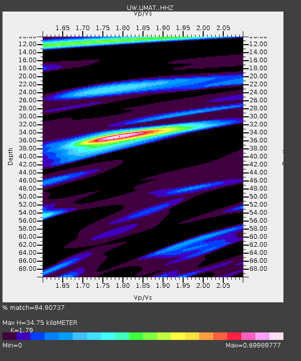
| Estimated Moho Depth: |
34.75 km |
| Estimated Crust Vp/Vs: |
1.79 |
| Assumed Crust Vp: |
6.571 km/s |
| Estimated Crust Vs: |
3.671 km/s |
| Estimated Crust Poisson's Ratio: |
0.27 |
|
| Radial Match: |
94.90737 % |
| Radial Bump: |
364 |
| Transverse Match: |
89.60546 % |
| Transverse Bump: |
385 |
| SOD ConfigId: |
11737051 |
| Insert Time: |
2019-04-25 06:12:16.459 +0000 |
| GWidth: |
2.5 |
| Max Bumps: |
400 |
| Tol: |
0.001 |
|

Signal To Noise
| Channel | StoN | STA | LTA |
| UW:UMAT: :HHZ:20160812T01:39:09.608018Z | 4.8611064 | 3.1049225E-7 | 6.387276E-8 |
| UW:UMAT: :HHN:20160812T01:39:09.608018Z | 1.336497 | 6.747195E-8 | 5.0484182E-8 |
| UW:UMAT: :HHE:20160812T01:39:09.608018Z | 2.3080385 | 9.370819E-8 | 4.060079E-8 |
| Arrivals |
| Ps | 4.3 SECOND |
| PpPs | 14 SECOND |
| PsPs/PpSs | 19 SECOND |


