You are here: Home > Network List > XD14 - Illuminating the architecture of the greater Mount St. Helens magmatic systems f Stations List
> Station MP04 "Mount St Helens, WA" > Earthquake Result Viewer
MP04 "Mount St Helens, WA" - Earthquake Result Viewer
| Earthquake location: |
Southeast Of Loyalty Islands |
| Earthquake latitude/longitude: |
-22.5/173.1 |
| Earthquake time(UTC): |
2016/08/12 (225) 01:26:35 GMT |
| Earthquake Depth: |
10 km |
| Earthquake Magnitude: |
7.2 MWW, 7.6 MI |
| Earthquake Catalog/Contributor: |
NEIC PDE/NEIC COMCAT |
|
| Network: |
XD Illuminating the architecture of the greater Mount St. Helens magmatic systems f |
| Station: |
MP04 "Mount St Helens, WA" |
| Lat/Lon: |
45.81 N/122.38 W |
| Elevation: |
497 m |
|
| Distance: |
89.6 deg |
| Az: |
39.148 deg |
| Baz: |
236.594 deg |
| Ray Param: |
0.041731168 |
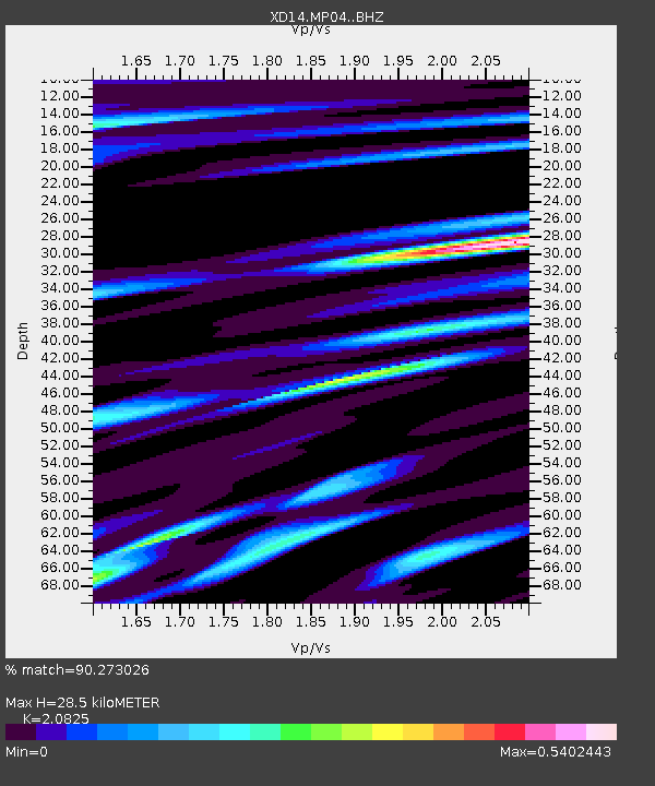
| Estimated Moho Depth: |
28.5 km |
| Estimated Crust Vp/Vs: |
2.08 |
| Assumed Crust Vp: |
6.566 km/s |
| Estimated Crust Vs: |
3.153 km/s |
| Estimated Crust Poisson's Ratio: |
0.35 |
|
| Radial Match: |
90.273026 % |
| Radial Bump: |
400 |
| Transverse Match: |
81.61883 % |
| Transverse Bump: |
400 |
| SOD ConfigId: |
11737051 |
| Insert Time: |
2019-04-25 06:13:18.081 +0000 |
| GWidth: |
2.5 |
| Max Bumps: |
400 |
| Tol: |
0.001 |
|

Signal To Noise
| Channel | StoN | STA | LTA |
| XD:MP04: :BHZ:20160812T01:39:01.480027Z | 2.653449 | 6.3780107E-7 | 2.403668E-7 |
| XD:MP04: :BHN:20160812T01:39:01.480027Z | 1.2837677 | 2.0015453E-7 | 1.5591179E-7 |
| XD:MP04: :BHE:20160812T01:39:01.480027Z | 1.6287977 | 2.280296E-7 | 1.3999873E-7 |
| Arrivals |
| Ps | 4.8 SECOND |
| PpPs | 13 SECOND |
| PsPs/PpSs | 18 SECOND |


