You are here: Home > Network List > XV14 - Fault Locations and Alaska Tectonics from Seismicity Stations List
> Station FTGH Toghotthele, Parks Hwy, AK, USA > Earthquake Result Viewer
FTGH Toghotthele, Parks Hwy, AK, USA - Earthquake Result Viewer
| Earthquake location: |
Southeast Of Loyalty Islands |
| Earthquake latitude/longitude: |
-22.5/173.1 |
| Earthquake time(UTC): |
2016/08/12 (225) 01:26:35 GMT |
| Earthquake Depth: |
10 km |
| Earthquake Magnitude: |
7.2 MWW, 7.6 MI |
| Earthquake Catalog/Contributor: |
NEIC PDE/NEIC COMCAT |
|
| Network: |
XV Fault Locations and Alaska Tectonics from Seismicity |
| Station: |
FTGH Toghotthele, Parks Hwy, AK, USA |
| Lat/Lon: |
64.69 N/148.83 W |
| Elevation: |
286 m |
|
| Distance: |
91.7 deg |
| Az: |
15.374 deg |
| Baz: |
214.779 deg |
| Ray Param: |
0.04156288 |
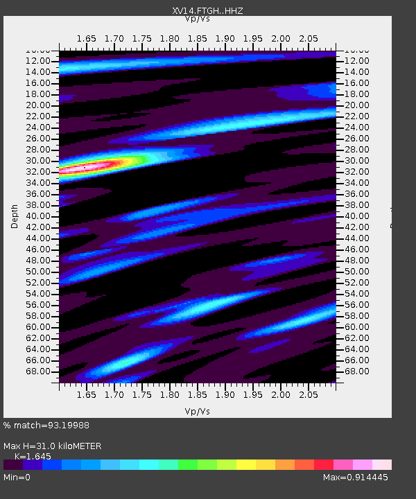
| Estimated Moho Depth: |
31.0 km |
| Estimated Crust Vp/Vs: |
1.64 |
| Assumed Crust Vp: |
6.566 km/s |
| Estimated Crust Vs: |
3.992 km/s |
| Estimated Crust Poisson's Ratio: |
0.21 |
|
| Radial Match: |
93.19988 % |
| Radial Bump: |
400 |
| Transverse Match: |
87.11188 % |
| Transverse Bump: |
400 |
| SOD ConfigId: |
11737051 |
| Insert Time: |
2019-04-25 06:13:27.814 +0000 |
| GWidth: |
2.5 |
| Max Bumps: |
400 |
| Tol: |
0.001 |
|

Signal To Noise
| Channel | StoN | STA | LTA |
| XV:FTGH: :HHZ:20160812T01:39:11.270005Z | 11.485597 | 6.7389834E-7 | 5.8673344E-8 |
| XV:FTGH: :HHN:20160812T01:39:11.270005Z | 2.2404633 | 1.4046982E-7 | 6.269678E-8 |
| XV:FTGH: :HHE:20160812T01:39:11.270005Z | 1.4771187 | 1.0720007E-7 | 7.257377E-8 |
| Arrivals |
| Ps | 3.1 SECOND |
| PpPs | 12 SECOND |
| PsPs/PpSs | 15 SECOND |


