You are here: Home > Network List > YN10 - San Jacinto Fault Zone Stations List
> Station JF00 JF00 > Earthquake Result Viewer
JF00 JF00 - Earthquake Result Viewer
| Earthquake location: |
Southeast Of Loyalty Islands |
| Earthquake latitude/longitude: |
-22.5/173.1 |
| Earthquake time(UTC): |
2016/08/12 (225) 01:26:35 GMT |
| Earthquake Depth: |
10 km |
| Earthquake Magnitude: |
7.2 MWW, 7.6 MI |
| Earthquake Catalog/Contributor: |
NEIC PDE/NEIC COMCAT |
|
| Network: |
YN San Jacinto Fault Zone |
| Station: |
JF00 JF00 |
| Lat/Lon: |
33.42 N/116.40 W |
| Elevation: |
646 m |
|
| Distance: |
87.1 deg |
| Az: |
52.116 deg |
| Baz: |
240.783 deg |
| Ray Param: |
0.043534324 |
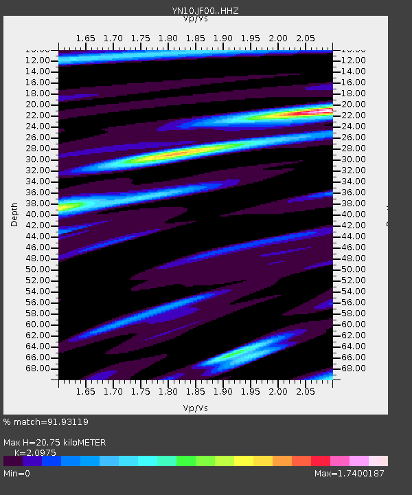
| Estimated Moho Depth: |
20.75 km |
| Estimated Crust Vp/Vs: |
2.10 |
| Assumed Crust Vp: |
6.264 km/s |
| Estimated Crust Vs: |
2.986 km/s |
| Estimated Crust Poisson's Ratio: |
0.35 |
|
| Radial Match: |
91.93119 % |
| Radial Bump: |
400 |
| Transverse Match: |
83.12871 % |
| Transverse Bump: |
400 |
| SOD ConfigId: |
11737051 |
| Insert Time: |
2019-04-25 06:13:36.164 +0000 |
| GWidth: |
2.5 |
| Max Bumps: |
400 |
| Tol: |
0.001 |
|

Signal To Noise
| Channel | StoN | STA | LTA |
| YN:JF00: :HHZ:20160812T01:38:49.749009Z | 3.2179239 | 4.1114575E-7 | 1.277674E-7 |
| YN:JF00: :HHN:20160812T01:38:49.749009Z | 1.0441098 | 1.285504E-7 | 1.2311962E-7 |
| YN:JF00: :HHE:20160812T01:38:49.749009Z | 1.5202281 | 1.3615971E-7 | 8.956531E-8 |
| Arrivals |
| Ps | 3.7 SECOND |
| PpPs | 10 SECOND |
| PsPs/PpSs | 14 SECOND |


