You are here: Home > Network List > YN10 - San Jacinto Fault Zone Stations List
> Station TR03 TR03 > Earthquake Result Viewer
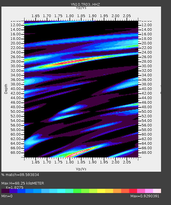
TR03 TR03 - Earthquake Result Viewer
| Earthquake location: |
Southeast Of Loyalty Islands |
| Earthquake latitude/longitude: |
-22.5/173.1 |
| Earthquake time(UTC): |
2016/08/12 (225) 01:26:35 GMT |
| Earthquake Depth: |
10 km |
| Earthquake Magnitude: |
7.2 MWW, 7.6 MI |
| Earthquake Catalog/Contributor: |
NEIC PDE/NEIC COMCAT |
|
| Network: |
YN San Jacinto Fault Zone |
| Station: |
TR03 TR03 |
| Lat/Lon: |
33.41 N/116.42 W |
| Elevation: |
739 m |
|
| Distance: |
87.1 deg |
| Az: |
52.12 deg |
| Baz: |
240.772 deg |
| Ray Param: |
0.043550488 |
| Estimated Moho Depth: |
68.25 km |
| Estimated Crust Vp/Vs: |
1.83 |
| Assumed Crust Vp: |
6.264 km/s |
| Estimated Crust Vs: |
3.427 km/s |
| Estimated Crust Poisson's Ratio: |
0.29 |
|
| Radial Match: |
89.593834 % |
| Radial Bump: |
395 |
| Transverse Match: |
86.07421 % |
| Transverse Bump: |
400 |
| SOD ConfigId: |
11737051 |
| Insert Time: |
2019-04-25 06:13:45.628 +0000 |
| GWidth: |
2.5 |
| Max Bumps: |
400 |
| Tol: |
0.001 |
|

Signal To Noise
| Channel | StoN | STA | LTA |
| YN:TR03: :HHZ:20160812T01:38:49.644028Z | 3.1518385 | 4.3318283E-7 | 1.3743815E-7 |
| YN:TR03: :HHN:20160812T01:38:49.644028Z | 1.1307179 | 1.0989878E-7 | 9.719381E-8 |
| YN:TR03: :HHE:20160812T01:38:49.644028Z | 0.9709909 | 1.2075556E-7 | 1.2436323E-7 |
| Arrivals |
| Ps | 9.2 SECOND |
| PpPs | 30 SECOND |
| PsPs/PpSs | 39 SECOND |


