You are here: Home > Network List > YT07 - POLENET Stations List
> Station SILY SILY > Earthquake Result Viewer
SILY SILY - Earthquake Result Viewer
| Earthquake location: |
Southeast Of Loyalty Islands |
| Earthquake latitude/longitude: |
-22.5/173.1 |
| Earthquake time(UTC): |
2016/08/12 (225) 01:26:35 GMT |
| Earthquake Depth: |
10 km |
| Earthquake Magnitude: |
7.2 MWW, 7.6 MI |
| Earthquake Catalog/Contributor: |
NEIC PDE/NEIC COMCAT |
|
| Network: |
YT POLENET |
| Station: |
SILY SILY |
| Lat/Lon: |
77.13 S/125.97 W |
| Elevation: |
2093 m |
|
| Distance: |
61.9 deg |
| Az: |
167.168 deg |
| Baz: |
293.579 deg |
| Ray Param: |
0.060599193 |
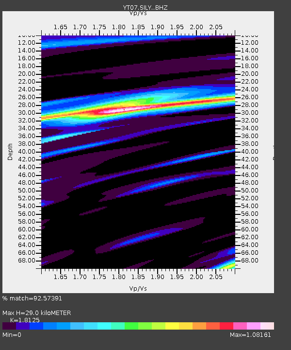
| Estimated Moho Depth: |
29.0 km |
| Estimated Crust Vp/Vs: |
1.81 |
| Assumed Crust Vp: |
6.138 km/s |
| Estimated Crust Vs: |
3.386 km/s |
| Estimated Crust Poisson's Ratio: |
0.28 |
|
| Radial Match: |
92.57391 % |
| Radial Bump: |
400 |
| Transverse Match: |
91.14403 % |
| Transverse Bump: |
400 |
| SOD ConfigId: |
11737051 |
| Insert Time: |
2019-04-25 06:14:06.523 +0000 |
| GWidth: |
2.5 |
| Max Bumps: |
400 |
| Tol: |
0.001 |
|

Signal To Noise
| Channel | StoN | STA | LTA |
| YT:SILY: :BHZ:20160812T01:36:23.648972Z | 11.863003 | 1.6680239E-6 | 1.4060721E-7 |
| YT:SILY: :BHN:20160812T01:36:23.648972Z | 3.5572512 | 6.565695E-7 | 1.8457214E-7 |
| YT:SILY: :BHE:20160812T01:36:23.648972Z | 1.6875079 | 1.5652205E-6 | 9.2753373E-7 |
| Arrivals |
| Ps | 4.0 SECOND |
| PpPs | 13 SECOND |
| PsPs/PpSs | 17 SECOND |


