You are here: Home > Network List > AV - Alaska Volcano Observatory Stations List
> Station AMKA Regional Station, Amchitka Island, Alaska > Earthquake Result Viewer
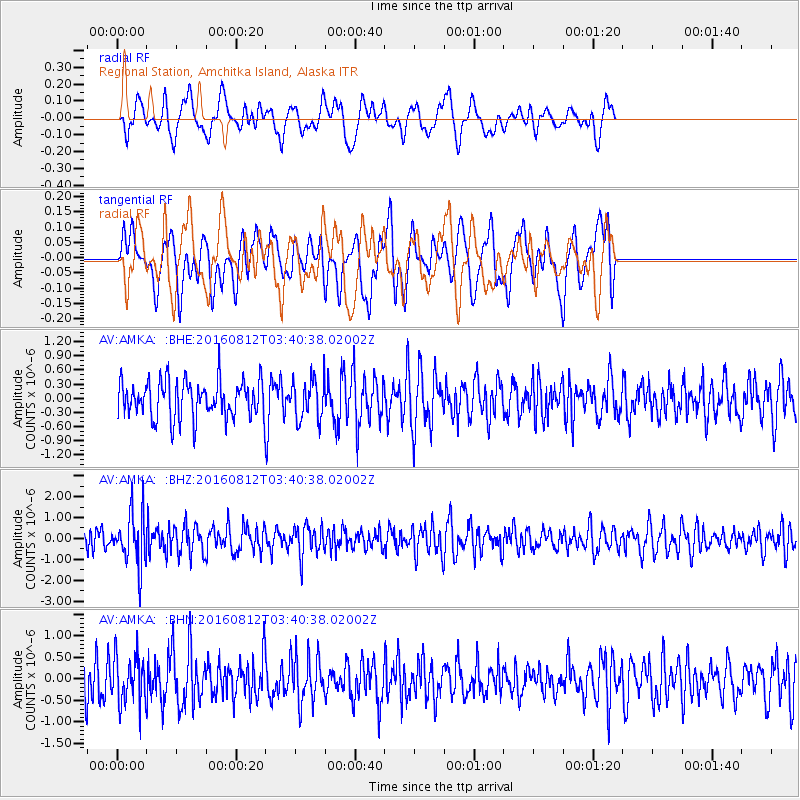
AMKA Regional Station, Amchitka Island, Alaska - Earthquake Result Viewer
*The percent match for this event was below the threshold and hence no stack was calculated.
| Earthquake location: |
South Of Fiji Islands |
| Earthquake latitude/longitude: |
-25.2/-177.0 |
| Earthquake time(UTC): |
2016/08/12 (225) 03:29:27 GMT |
| Earthquake Depth: |
75 km |
| Earthquake Magnitude: |
6.1 MO |
| Earthquake Catalog/Contributor: |
NEIC PDE/NEIC ALERT |
|
| Network: |
AV Alaska Volcano Observatory |
| Station: |
AMKA Regional Station, Amchitka Island, Alaska |
| Lat/Lon: |
51.38 N/179.30 E |
| Elevation: |
116 m |
|
| Distance: |
76.3 deg |
| Az: |
357.619 deg |
| Baz: |
176.557 deg |
| Ray Param: |
$rayparam |
*The percent match for this event was below the threshold and hence was not used in the summary stack. |
|
| Radial Match: |
52.01386 % |
| Radial Bump: |
400 |
| Transverse Match: |
55.509804 % |
| Transverse Bump: |
400 |
| SOD ConfigId: |
11737051 |
| Insert Time: |
2019-04-25 06:15:42.497 +0000 |
| GWidth: |
2.5 |
| Max Bumps: |
400 |
| Tol: |
0.001 |
|
Signal To Noise
| Channel | StoN | STA | LTA |
| AV:AMKA: :BHZ:20160812T03:40:38.02002Z | 2.87288 | 1.2429296E-6 | 4.3264237E-7 |
| AV:AMKA: :BHN:20160812T03:40:38.02002Z | 1.4827532 | 5.4651025E-7 | 3.6857801E-7 |
| AV:AMKA: :BHE:20160812T03:40:38.02002Z | 0.9509527 | 3.6756248E-7 | 3.8652024E-7 |
| Arrivals |
| Ps | |
| PpPs | |
| PsPs/PpSs | |


