You are here: Home > Network List > CI - Caltech Regional Seismic Network Stations List
> Station TIN Tinemaha, Big Pine, CA, USA > Earthquake Result Viewer
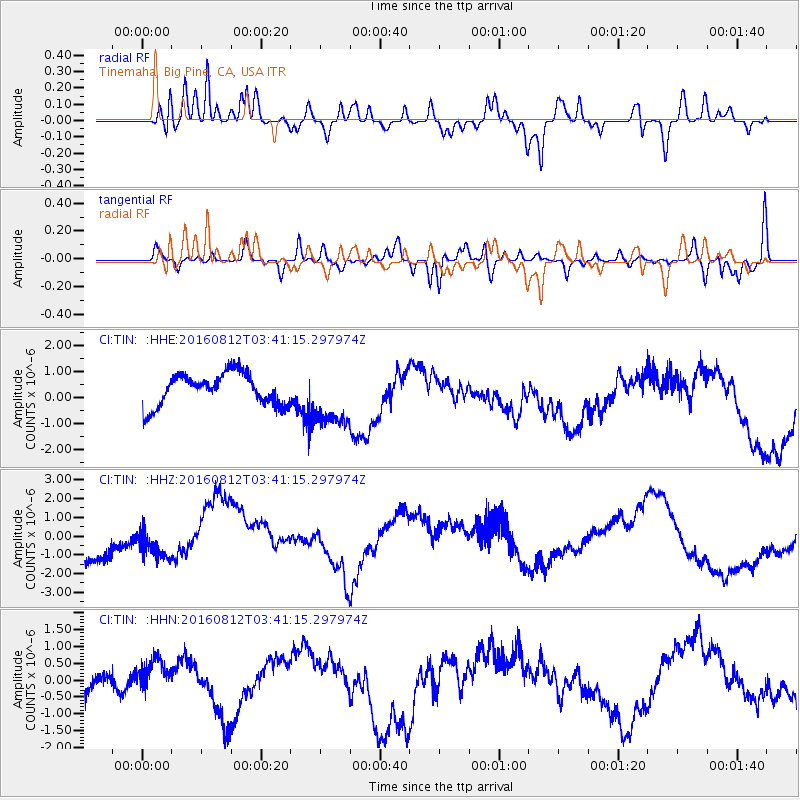
TIN Tinemaha, Big Pine, CA, USA - Earthquake Result Viewer
*The percent match for this event was below the threshold and hence no stack was calculated.
| Earthquake location: |
South Of Fiji Islands |
| Earthquake latitude/longitude: |
-25.2/-177.0 |
| Earthquake time(UTC): |
2016/08/12 (225) 03:29:27 GMT |
| Earthquake Depth: |
75 km |
| Earthquake Magnitude: |
6.1 MO |
| Earthquake Catalog/Contributor: |
NEIC PDE/NEIC ALERT |
|
| Network: |
CI Caltech Regional Seismic Network |
| Station: |
TIN Tinemaha, Big Pine, CA, USA |
| Lat/Lon: |
37.05 N/118.23 W |
| Elevation: |
1197 m |
|
| Distance: |
83.0 deg |
| Az: |
43.57 deg |
| Baz: |
231.309 deg |
| Ray Param: |
$rayparam |
*The percent match for this event was below the threshold and hence was not used in the summary stack. |
|
| Radial Match: |
71.806885 % |
| Radial Bump: |
400 |
| Transverse Match: |
58.94019 % |
| Transverse Bump: |
400 |
| SOD ConfigId: |
11737051 |
| Insert Time: |
2019-04-25 06:17:01.675 +0000 |
| GWidth: |
2.5 |
| Max Bumps: |
400 |
| Tol: |
0.001 |
|
Signal To Noise
| Channel | StoN | STA | LTA |
| CI:TIN: :HHZ:20160812T03:41:15.297974Z | 0.7015339 | 8.468225E-7 | 1.2071013E-6 |
| CI:TIN: :HHN:20160812T03:41:15.297974Z | 0.50863767 | 4.821232E-7 | 9.478715E-7 |
| CI:TIN: :HHE:20160812T03:41:15.297974Z | 2.0738554 | 1.2369211E-6 | 5.9643554E-7 |
| Arrivals |
| Ps | |
| PpPs | |
| PsPs/PpSs | |


