You are here: Home > Network List > US - United States National Seismic Network Stations List
> Station OXF Oxford, Mississippi, USA > Earthquake Result Viewer
OXF Oxford, Mississippi, USA - Earthquake Result Viewer
| Earthquake location: |
Alaska Peninsula |
| Earthquake latitude/longitude: |
54.7/-161.2 |
| Earthquake time(UTC): |
1999/10/13 (286) 01:33:40 GMT |
| Earthquake Depth: |
30 km |
| Earthquake Magnitude: |
6.0 MB, 6.2 MS, 6.5 MW, 6.0 ML |
| Earthquake Catalog/Contributor: |
WHDF/NEIC |
|
| Network: |
US United States National Seismic Network |
| Station: |
OXF Oxford, Mississippi, USA |
| Lat/Lon: |
34.51 N/89.41 W |
| Elevation: |
101 m |
|
| Distance: |
52.5 deg |
| Az: |
81.475 deg |
| Baz: |
315.903 deg |
| Ray Param: |
0.06668049 |
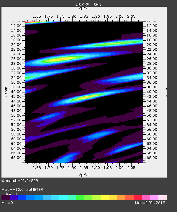
| Estimated Moho Depth: |
10.0 km |
| Estimated Crust Vp/Vs: |
1.60 |
| Assumed Crust Vp: |
6.38 km/s |
| Estimated Crust Vs: |
3.988 km/s |
| Estimated Crust Poisson's Ratio: |
0.18 |
|
| Radial Match: |
91.24809 % |
| Radial Bump: |
400 |
| Transverse Match: |
78.08949 % |
| Transverse Bump: |
400 |
| SOD ConfigId: |
110177 |
| Insert Time: |
2010-03-05 06:02:42.083 +0000 |
| GWidth: |
2.5 |
| Max Bumps: |
400 |
| Tol: |
0.001 |
|

Signal To Noise
| Channel | StoN | STA | LTA |
| US:OXF: :BHN:19991013T01:42:19.473018Z | 1.590662 | 5.158384E-7 | 3.2429165E-7 |
| US:OXF: :BHE:19991013T01:42:19.473018Z | 1.0447155 | 3.2793056E-7 | 3.1389462E-7 |
| US:OXF: :BHZ:19991013T01:42:19.473018Z | 4.201306 | 6.10461E-7 | 1.4530268E-7 |
| Arrivals |
| Ps | 1.0 SECOND |
| PpPs | 3.8 SECOND |
| PsPs/PpSs | 4.8 SECOND |


