You are here: Home > Network List > TA - USArray Transportable Network (new EarthScope stations) Stations List
> Station G21K Allakaket, AK, USA > Earthquake Result Viewer
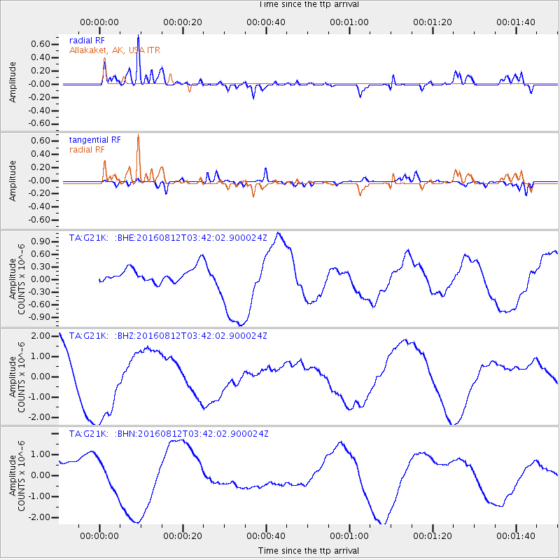
G21K Allakaket, AK, USA - Earthquake Result Viewer
*The percent match for this event was below the threshold and hence no stack was calculated.
| Earthquake location: |
South Of Fiji Islands |
| Earthquake latitude/longitude: |
-25.2/-177.0 |
| Earthquake time(UTC): |
2016/08/12 (225) 03:29:27 GMT |
| Earthquake Depth: |
75 km |
| Earthquake Magnitude: |
6.1 MO |
| Earthquake Catalog/Contributor: |
NEIC PDE/NEIC ALERT |
|
| Network: |
TA USArray Transportable Network (new EarthScope stations) |
| Station: |
G21K Allakaket, AK, USA |
| Lat/Lon: |
66.52 N/153.51 W |
| Elevation: |
446 m |
|
| Distance: |
93.1 deg |
| Az: |
9.209 deg |
| Baz: |
201.21 deg |
| Ray Param: |
$rayparam |
*The percent match for this event was below the threshold and hence was not used in the summary stack. |
|
| Radial Match: |
92.46693 % |
| Radial Bump: |
332 |
| Transverse Match: |
69.99744 % |
| Transverse Bump: |
400 |
| SOD ConfigId: |
11737051 |
| Insert Time: |
2019-04-25 06:19:29.177 +0000 |
| GWidth: |
2.5 |
| Max Bumps: |
400 |
| Tol: |
0.001 |
|
Signal To Noise
| Channel | StoN | STA | LTA |
| TA:G21K: :BHZ:20160812T03:42:02.900024Z | 2.002966 | 2.123009E-6 | 1.0599326E-6 |
| TA:G21K: :BHN:20160812T03:42:02.900024Z | 0.87087876 | 7.0380656E-7 | 8.081568E-7 |
| TA:G21K: :BHE:20160812T03:42:02.900024Z | 6.260104 | 8.0508414E-7 | 1.2860555E-7 |
| Arrivals |
| Ps | |
| PpPs | |
| PsPs/PpSs | |


