You are here: Home > Network List > TA - USArray Transportable Network (new EarthScope stations) Stations List
> Station O18K Koktuh Hills, AK, USA > Earthquake Result Viewer
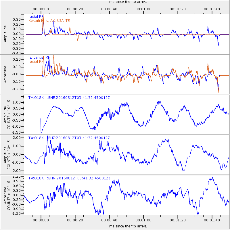
O18K Koktuh Hills, AK, USA - Earthquake Result Viewer
*The percent match for this event was below the threshold and hence no stack was calculated.
| Earthquake location: |
South Of Fiji Islands |
| Earthquake latitude/longitude: |
-25.2/-177.0 |
| Earthquake time(UTC): |
2016/08/12 (225) 03:29:27 GMT |
| Earthquake Depth: |
75 km |
| Earthquake Magnitude: |
6.1 MO |
| Earthquake Catalog/Contributor: |
NEIC PDE/NEIC ALERT |
|
| Network: |
TA USArray Transportable Network (new EarthScope stations) |
| Station: |
O18K Koktuh Hills, AK, USA |
| Lat/Lon: |
59.85 N/155.21 W |
| Elevation: |
544 m |
|
| Distance: |
86.6 deg |
| Az: |
10.821 deg |
| Baz: |
199.694 deg |
| Ray Param: |
$rayparam |
*The percent match for this event was below the threshold and hence was not used in the summary stack. |
|
| Radial Match: |
70.286674 % |
| Radial Bump: |
400 |
| Transverse Match: |
54.927685 % |
| Transverse Bump: |
400 |
| SOD ConfigId: |
11737051 |
| Insert Time: |
2019-04-25 06:19:43.011 +0000 |
| GWidth: |
2.5 |
| Max Bumps: |
400 |
| Tol: |
0.001 |
|
Signal To Noise
| Channel | StoN | STA | LTA |
| TA:O18K: :BHZ:20160812T03:41:32.450012Z | 1.7380948 | 7.765209E-7 | 4.4676554E-7 |
| TA:O18K: :BHN:20160812T03:41:32.450012Z | 0.9726354 | 4.156795E-7 | 4.2737443E-7 |
| TA:O18K: :BHE:20160812T03:41:32.450012Z | 1.9888157 | 1.0870015E-6 | 5.465572E-7 |
| Arrivals |
| Ps | |
| PpPs | |
| PsPs/PpSs | |


