You are here: Home > Network List > US - United States National Seismic Network Stations List
> Station OXF Oxford, Mississippi, USA > Earthquake Result Viewer
OXF Oxford, Mississippi, USA - Earthquake Result Viewer
| Earthquake location: |
Southern Alaska |
| Earthquake latitude/longitude: |
59.0/-155.1 |
| Earthquake time(UTC): |
2001/07/28 (209) 07:32:43 GMT |
| Earthquake Depth: |
131 km |
| Earthquake Magnitude: |
5.7 MB, 5.7 MS, 6.6 MW, 6.2 ME |
| Earthquake Catalog/Contributor: |
WHDF/NEIC |
|
| Network: |
US United States National Seismic Network |
| Station: |
OXF Oxford, Mississippi, USA |
| Lat/Lon: |
34.51 N/89.41 W |
| Elevation: |
101 m |
|
| Distance: |
48.8 deg |
| Az: |
89.929 deg |
| Baz: |
321.22 deg |
| Ray Param: |
0.06864747 |
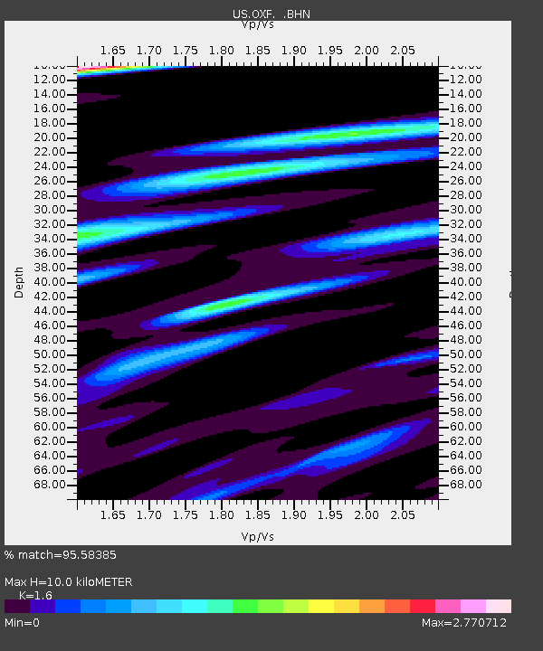
| Estimated Moho Depth: |
10.0 km |
| Estimated Crust Vp/Vs: |
1.60 |
| Assumed Crust Vp: |
6.38 km/s |
| Estimated Crust Vs: |
3.988 km/s |
| Estimated Crust Poisson's Ratio: |
0.18 |
|
| Radial Match: |
95.58385 % |
| Radial Bump: |
400 |
| Transverse Match: |
85.95401 % |
| Transverse Bump: |
400 |
| SOD ConfigId: |
110165 |
| Insert Time: |
2010-03-05 06:04:15.230 +0000 |
| GWidth: |
2.5 |
| Max Bumps: |
400 |
| Tol: |
0.001 |
|
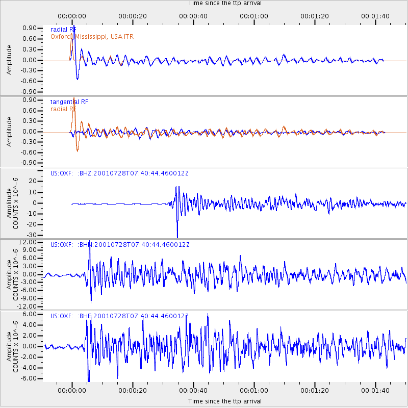
Signal To Noise
| Channel | StoN | STA | LTA |
| US:OXF: :BHN:20010728T07:40:44.460012Z | 2.277732 | 9.397433E-7 | 4.1257854E-7 |
| US:OXF: :BHE:20010728T07:40:44.460012Z | 3.7280242 | 9.904123E-7 | 2.656668E-7 |
| US:OXF: :BHZ:20010728T07:40:44.460012Z | 57.269142 | 7.248291E-6 | 1.2656538E-7 |
| Arrivals |
| Ps | 1.0 SECOND |
| PpPs | 3.8 SECOND |
| PsPs/PpSs | 4.8 SECOND |


