You are here: Home > Network List > US - United States National Seismic Network Stations List
> Station OXF Oxford, Mississippi, USA > Earthquake Result Viewer
OXF Oxford, Mississippi, USA - Earthquake Result Viewer
| Earthquake location: |
Off Coast Of Oregon |
| Earthquake latitude/longitude: |
44.3/-129.0 |
| Earthquake time(UTC): |
2003/01/16 (016) 00:53:15 GMT |
| Earthquake Depth: |
10 km |
| Earthquake Magnitude: |
5.4 MB, 6.0 MS, 6.2 MW, 6.2 MW |
| Earthquake Catalog/Contributor: |
WHDF/NEIC |
|
| Network: |
US United States National Seismic Network |
| Station: |
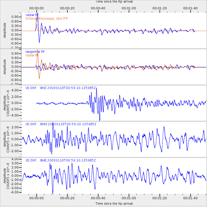
OXF Oxford, Mississippi, USA |
| Lat/Lon: |
34.51 N/89.41 W |
| Elevation: |
101 m |
|
| Distance: |
31.9 deg |
| Az: |
94.08 deg |
| Baz: |
299.825 deg |
| Ray Param: |
0.07889672 |
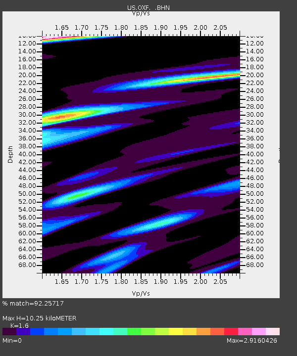
| Estimated Moho Depth: |
10.25 km |
| Estimated Crust Vp/Vs: |
1.60 |
| Assumed Crust Vp: |
6.38 km/s |
| Estimated Crust Vs: |
3.988 km/s |
| Estimated Crust Poisson's Ratio: |
0.18 |
|
| Radial Match: |
92.25717 % |
| Radial Bump: |
384 |
| Transverse Match: |
72.93502 % |
| Transverse Bump: |
400 |
| SOD ConfigId: |
110177 |
| Insert Time: |
2010-03-05 06:05:00.151 +0000 |
| GWidth: |
2.5 |
| Max Bumps: |
400 |
| Tol: |
0.001 |
|
Signal To Noise
| Channel | StoN | STA | LTA |
| US:OXF: :BHN:20030116T00:59:10.135985Z | 1.1492256 | 4.114312E-7 | 3.5800733E-7 |
| US:OXF: :BHE:20030116T00:59:10.135985Z | 0.83658403 | 3.1084429E-7 | 3.7156374E-7 |
| US:OXF: :BHZ:20030116T00:59:10.135985Z | 4.287987 | 6.86074E-7 | 1.5999908E-7 |
| Arrivals |
| Ps | 1.1 SECOND |
| PpPs | 3.8 SECOND |
| PsPs/PpSs | 4.9 SECOND |


