You are here: Home > Network List > NE - New England Seismic Network Stations List
> Station FFD Franklin Falls Dam, NH, USA > Earthquake Result Viewer
FFD Franklin Falls Dam, NH, USA - Earthquake Result Viewer
| Earthquake location: |
Off Coast Of Central Chile |
| Earthquake latitude/longitude: |
-29.7/-72.1 |
| Earthquake time(UTC): |
2015/09/19 (262) 05:06:47 GMT |
| Earthquake Depth: |
10 km |
| Earthquake Magnitude: |
5.8 MWR |
| Earthquake Catalog/Contributor: |
NEIC PDE/NEIC COMCAT |
|
| Network: |
NE New England Seismic Network |
| Station: |
FFD Franklin Falls Dam, NH, USA |
| Lat/Lon: |
43.47 N/71.65 W |
| Elevation: |
131 m |
|
| Distance: |
72.8 deg |
| Az: |
0.357 deg |
| Baz: |
180.426 deg |
| Ray Param: |
0.053441737 |
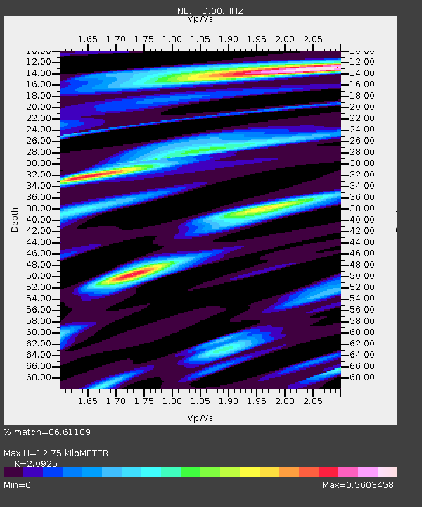
| Estimated Moho Depth: |
12.75 km |
| Estimated Crust Vp/Vs: |
2.09 |
| Assumed Crust Vp: |
6.419 km/s |
| Estimated Crust Vs: |
3.068 km/s |
| Estimated Crust Poisson's Ratio: |
0.35 |
|
| Radial Match: |
86.61189 % |
| Radial Bump: |
319 |
| Transverse Match: |
77.98196 % |
| Transverse Bump: |
400 |
| SOD ConfigId: |
1156111 |
| Insert Time: |
2015-10-03 05:30:55.371 +0000 |
| GWidth: |
2.5 |
| Max Bumps: |
400 |
| Tol: |
0.001 |
|

Signal To Noise
| Channel | StoN | STA | LTA |
| NE:FFD:00:HHZ:20150919T05:17:44.224023Z | 3.348304 | 3.7885215E-7 | 1.1314747E-7 |
| NE:FFD:00:HH1:20150919T05:17:44.224023Z | 1.3493704 | 1.9024414E-7 | 1.4098734E-7 |
| NE:FFD:00:HH2:20150919T05:17:44.224023Z | 0.7545257 | 8.6753595E-8 | 1.1497765E-7 |
| Arrivals |
| Ps | 2.2 SECOND |
| PpPs | 6.0 SECOND |
| PsPs/PpSs | 8.2 SECOND |


