You are here: Home > Network List > NE - New England Seismic Network Stations List
> Station HNH Hanover, NH, USA > Earthquake Result Viewer
HNH Hanover, NH, USA - Earthquake Result Viewer
| Earthquake location: |
Off Coast Of Central Chile |
| Earthquake latitude/longitude: |
-29.7/-72.1 |
| Earthquake time(UTC): |
2015/09/19 (262) 05:06:47 GMT |
| Earthquake Depth: |
10 km |
| Earthquake Magnitude: |
5.8 MWR |
| Earthquake Catalog/Contributor: |
NEIC PDE/NEIC COMCAT |
|
| Network: |
NE New England Seismic Network |
| Station: |
HNH Hanover, NH, USA |
| Lat/Lon: |
43.71 N/72.29 W |
| Elevation: |
180 m |
|
| Distance: |
73.0 deg |
| Az: |
359.875 deg |
| Baz: |
179.85 deg |
| Ray Param: |
0.05328853 |
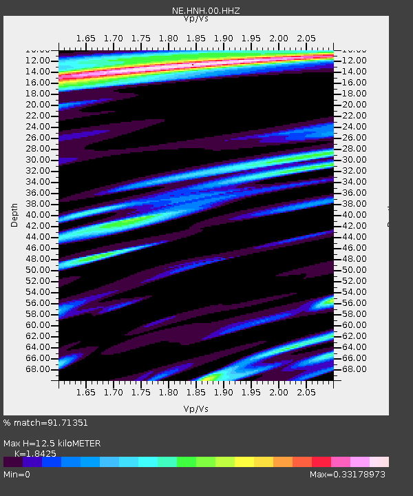
| Estimated Moho Depth: |
12.5 km |
| Estimated Crust Vp/Vs: |
1.84 |
| Assumed Crust Vp: |
6.419 km/s |
| Estimated Crust Vs: |
3.484 km/s |
| Estimated Crust Poisson's Ratio: |
0.29 |
|
| Radial Match: |
91.71351 % |
| Radial Bump: |
385 |
| Transverse Match: |
76.8596 % |
| Transverse Bump: |
395 |
| SOD ConfigId: |
1156111 |
| Insert Time: |
2015-10-03 05:30:56.459 +0000 |
| GWidth: |
2.5 |
| Max Bumps: |
400 |
| Tol: |
0.001 |
|

Signal To Noise
| Channel | StoN | STA | LTA |
| NE:HNH:00:HHZ:20150919T05:17:45.604028Z | 2.6924067 | 4.943521E-7 | 1.8360976E-7 |
| NE:HNH:00:HH1:20150919T05:17:45.604028Z | 2.1203907 | 1.9286423E-7 | 9.095693E-8 |
| NE:HNH:00:HH2:20150919T05:17:45.604028Z | 1.1458887 | 8.0774484E-8 | 7.049069E-8 |
| Arrivals |
| Ps | 1.7 SECOND |
| PpPs | 5.4 SECOND |
| PsPs/PpSs | 7.1 SECOND |


