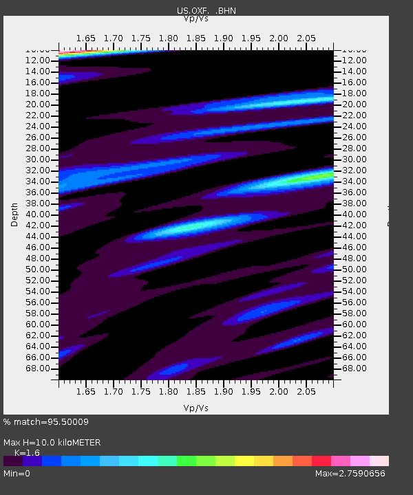
OXF Oxford, Mississippi, USA - Earthquake Result Viewer
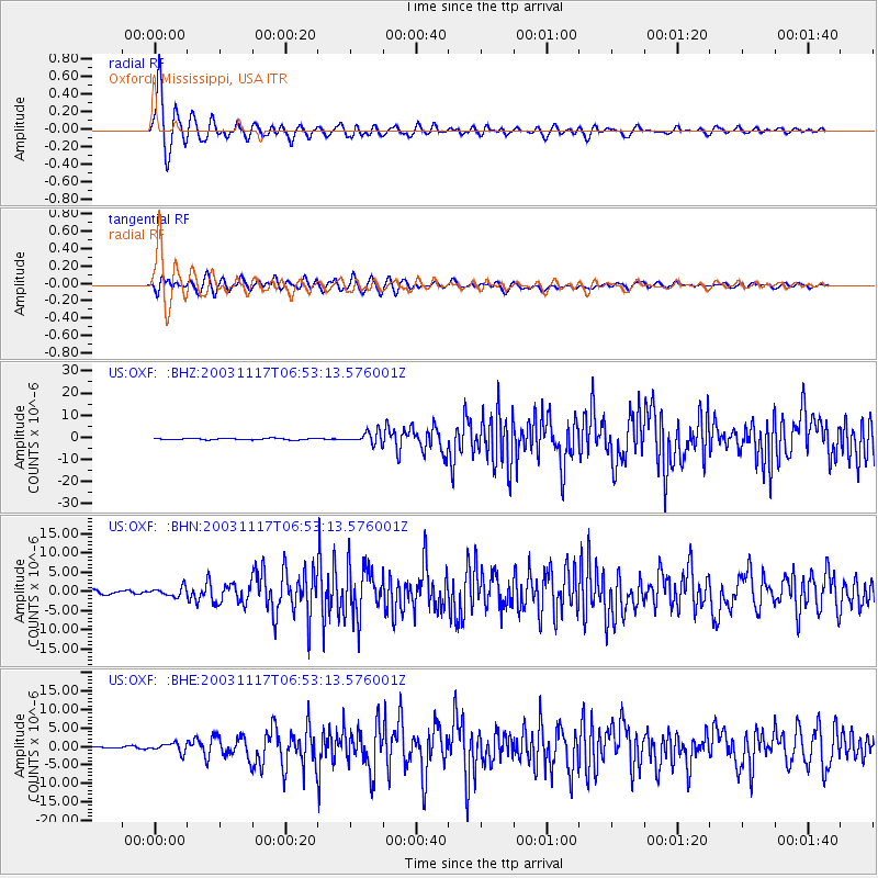
Earthquake location: Rat Islands, Aleutian Islands
Earthquake latitude/longitude: 51.1/178.6
Earthquake time(UTC): 2003/11/17 (321) 06:43:06 GMT
Earthquake Depth: 33 km
Earthquake Magnitude: 6.2 MB, 7.2 MS, 7.8 MW, 7.7 MW
Earthquake Catalog/Contributor: WHDF/NEIC
Network: US United States National Seismic Network
Station: OXF Oxford, Mississippi, USA
Lat/Lon: 34.51 N/89.41 W
Elevation: 101 m
Distance: 65.1 deg
Az: 65.45 deg
Baz: 316.066 deg
Ray Param: 0.058415443
Estimated Moho Depth: 10.0 km
Estimated Crust Vp/Vs: 1.60
Assumed Crust Vp: 6.38 km/s
Estimated Crust Vs: 3.988 km/s
Estimated Crust Poisson's Ratio: 0.18
Radial Match: 95.50009 %
Radial Bump: 400
Transverse Match: 85.97396 %
Transverse Bump: 400
SOD ConfigId: 110177
Insert Time: 2010-03-05 06:05:18.943 +0000
GWidth: 2.5
Max Bumps: 400
Tol: 0.001

Signal To Noise

ChannelStoNSTALTA
US:OXF: :BHN:20031117T06:53:13.576001Z2.30250841.2137433E-65.271396E-7
US:OXF: :BHE:20031117T06:53:13.576001Z2.9923551.2688811E-64.2404093E-7
US:OXF: :BHZ:20031117T06:53:13.576001Z8.6369842.644929E-63.0623292E-7
Arrivals
Ps1.0 SECOND
PpPs3.9 SECOND
PsPs/PpSs4.9 SECOND