You are here: Home > Network List > TA - USArray Transportable Network (new EarthScope stations) Stations List
> Station D25K Kavik River, AK, USA > Earthquake Result Viewer
D25K Kavik River, AK, USA - Earthquake Result Viewer
| Earthquake location: |
Sakhalin, Russia |
| Earthquake latitude/longitude: |
50.4/142.3 |
| Earthquake time(UTC): |
2016/08/14 (227) 11:15:14 GMT |
| Earthquake Depth: |
5.8 km |
| Earthquake Magnitude: |
5.7 MWW, 5.7 MWB, 5.8 MWC |
| Earthquake Catalog/Contributor: |
NEIC PDE/NEIC COMCAT |
|
| Network: |
TA USArray Transportable Network (new EarthScope stations) |
| Station: |
D25K Kavik River, AK, USA |
| Lat/Lon: |
69.32 N/146.38 W |
| Elevation: |
770 m |
|
| Distance: |
37.7 deg |
| Az: |
33.394 deg |
| Baz: |
277.668 deg |
| Ray Param: |
0.07600728 |
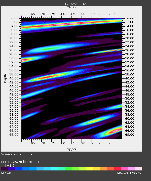
| Estimated Moho Depth: |
30.75 km |
| Estimated Crust Vp/Vs: |
1.60 |
| Assumed Crust Vp: |
6.378 km/s |
| Estimated Crust Vs: |
3.986 km/s |
| Estimated Crust Poisson's Ratio: |
0.18 |
|
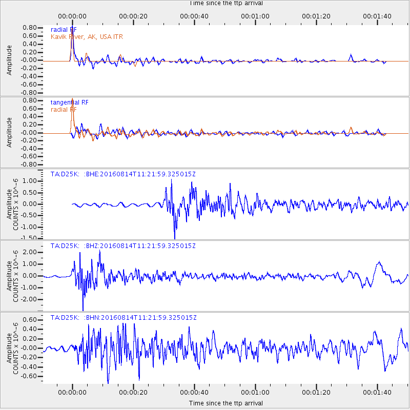
| Radial Match: |
87.35389 % |
| Radial Bump: |
400 |
| Transverse Match: |
82.94334 % |
| Transverse Bump: |
400 |
| SOD ConfigId: |
11737051 |
| Insert Time: |
2019-04-25 06:33:09.111 +0000 |
| GWidth: |
2.5 |
| Max Bumps: |
400 |
| Tol: |
0.001 |
|
Signal To Noise
| Channel | StoN | STA | LTA |
| TA:D25K: :BHZ:20160814T11:21:59.325015Z | 14.007073 | 9.555387E-7 | 6.821829E-8 |
| TA:D25K: :BHN:20160814T11:21:59.325015Z | 3.790053 | 1.5376199E-7 | 4.0569876E-8 |
| TA:D25K: :BHE:20160814T11:21:59.325015Z | 10.10201 | 5.297009E-7 | 5.24352E-8 |
| Arrivals |
| Ps | 3.1 SECOND |
| PpPs | 12 SECOND |
| PsPs/PpSs | 15 SECOND |


