You are here: Home > Network List > TA - USArray Transportable Network (new EarthScope stations) Stations List
> Station E22K Anaktuvuk Pass, AK, USA > Earthquake Result Viewer
E22K Anaktuvuk Pass, AK, USA - Earthquake Result Viewer
| Earthquake location: |
Sakhalin, Russia |
| Earthquake latitude/longitude: |
50.4/142.3 |
| Earthquake time(UTC): |
2016/08/14 (227) 11:15:14 GMT |
| Earthquake Depth: |
5.8 km |
| Earthquake Magnitude: |
5.7 MWW, 5.7 MWB, 5.8 MWC |
| Earthquake Catalog/Contributor: |
NEIC PDE/NEIC COMCAT |
|
| Network: |
TA USArray Transportable Network (new EarthScope stations) |
| Station: |
E22K Anaktuvuk Pass, AK, USA |
| Lat/Lon: |
68.13 N/151.81 W |
| Elevation: |
772 m |
|
| Distance: |
35.8 deg |
| Az: |
35.725 deg |
| Baz: |
274.472 deg |
| Ray Param: |
0.07701619 |
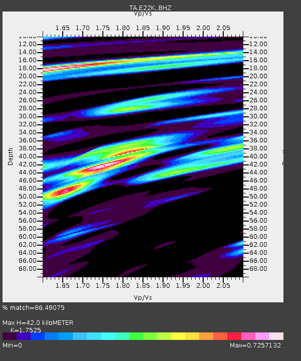
| Estimated Moho Depth: |
42.0 km |
| Estimated Crust Vp/Vs: |
1.75 |
| Assumed Crust Vp: |
6.221 km/s |
| Estimated Crust Vs: |
3.55 km/s |
| Estimated Crust Poisson's Ratio: |
0.26 |
|
| Radial Match: |
86.49075 % |
| Radial Bump: |
400 |
| Transverse Match: |
74.84629 % |
| Transverse Bump: |
400 |
| SOD ConfigId: |
11737051 |
| Insert Time: |
2019-04-25 06:33:09.947 +0000 |
| GWidth: |
2.5 |
| Max Bumps: |
400 |
| Tol: |
0.001 |
|

Signal To Noise
| Channel | StoN | STA | LTA |
| TA:E22K: :BHZ:20160814T11:21:43.625002Z | 19.461414 | 9.1715435E-7 | 4.712681E-8 |
| TA:E22K: :BHN:20160814T11:21:43.625002Z | 6.685142 | 2.1360255E-7 | 3.1951835E-8 |
| TA:E22K: :BHE:20160814T11:21:43.625002Z | 9.206972 | 5.3854274E-7 | 5.8492926E-8 |
| Arrivals |
| Ps | 5.5 SECOND |
| PpPs | 17 SECOND |
| PsPs/PpSs | 23 SECOND |


