You are here: Home > Network List > TA - USArray Transportable Network (new EarthScope stations) Stations List
> Station F21K Alatna River, AK, USA > Earthquake Result Viewer
F21K Alatna River, AK, USA - Earthquake Result Viewer

| Earthquake location: |
Sakhalin, Russia |
| Earthquake latitude/longitude: |
50.4/142.3 |
| Earthquake time(UTC): |
2016/08/14 (227) 11:15:14 GMT |
| Earthquake Depth: |
5.8 km |
| Earthquake Magnitude: |
5.7 MWW, 5.7 MWB, 5.8 MWC |
| Earthquake Catalog/Contributor: |
NEIC PDE/NEIC COMCAT |
|
| Network: |
TA USArray Transportable Network (new EarthScope stations) |
| Station: |
F21K Alatna River, AK, USA |
| Lat/Lon: |
67.22 N/153.48 W |
| Elevation: |
597 m |
|
| Distance: |
35.3 deg |
| Az: |
37.38 deg |
| Baz: |
274.275 deg |
| Ray Param: |
0.07731886 |
| Estimated Moho Depth: |
11.75 km |
| Estimated Crust Vp/Vs: |
2.05 |
| Assumed Crust Vp: |
6.455 km/s |
| Estimated Crust Vs: |
3.145 km/s |
| Estimated Crust Poisson's Ratio: |
0.34 |
|
| Radial Match: |
86.445 % |
| Radial Bump: |
400 |
| Transverse Match: |
77.84256 % |
| Transverse Bump: |
400 |
| SOD ConfigId: |
11737051 |
| Insert Time: |
2019-04-25 06:33:15.511 +0000 |
| GWidth: |
2.5 |
| Max Bumps: |
400 |
| Tol: |
0.001 |
|
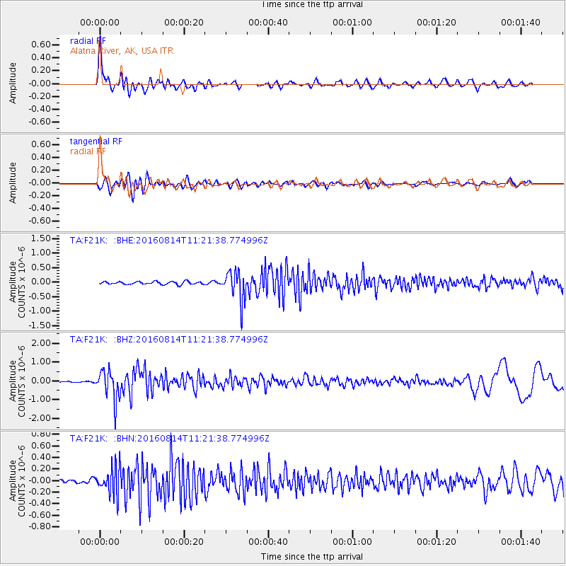
Signal To Noise
| Channel | StoN | STA | LTA |
| TA:F21K: :BHZ:20160814T11:21:38.774996Z | 19.445711 | 7.887489E-7 | 4.0561584E-8 |
| TA:F21K: :BHN:20160814T11:21:38.774996Z | 6.0520296 | 2.3773987E-7 | 3.9282668E-8 |
| TA:F21K: :BHE:20160814T11:21:38.774996Z | 10.710807 | 5.0593945E-7 | 4.723635E-8 |
| Arrivals |
| Ps | 2.0 SECOND |
| PpPs | 5.2 SECOND |
| PsPs/PpSs | 7.2 SECOND |


