You are here: Home > Network List > TA - USArray Transportable Network (new EarthScope stations) Stations List
> Station I27K Kandik River, AK, USA > Earthquake Result Viewer
I27K Kandik River, AK, USA - Earthquake Result Viewer
| Earthquake location: |
Sakhalin, Russia |
| Earthquake latitude/longitude: |
50.4/142.3 |
| Earthquake time(UTC): |
2016/08/14 (227) 11:15:14 GMT |
| Earthquake Depth: |
5.8 km |
| Earthquake Magnitude: |
5.7 MWW, 5.7 MWB, 5.8 MWC |
| Earthquake Catalog/Contributor: |
NEIC PDE/NEIC COMCAT |
|
| Network: |
TA USArray Transportable Network (new EarthScope stations) |
| Station: |
I27K Kandik River, AK, USA |
| Lat/Lon: |
65.60 N/141.62 W |
| Elevation: |
874 m |
|
| Distance: |
40.3 deg |
| Az: |
38.602 deg |
| Baz: |
286.113 deg |
| Ray Param: |
0.07451058 |
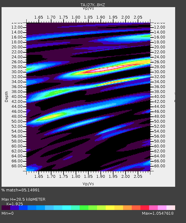
| Estimated Moho Depth: |
28.5 km |
| Estimated Crust Vp/Vs: |
1.92 |
| Assumed Crust Vp: |
6.566 km/s |
| Estimated Crust Vs: |
3.411 km/s |
| Estimated Crust Poisson's Ratio: |
0.32 |
|
| Radial Match: |
85.14991 % |
| Radial Bump: |
400 |
| Transverse Match: |
74.45349 % |
| Transverse Bump: |
400 |
| SOD ConfigId: |
11737051 |
| Insert Time: |
2019-04-25 06:33:38.307 +0000 |
| GWidth: |
2.5 |
| Max Bumps: |
400 |
| Tol: |
0.001 |
|

Signal To Noise
| Channel | StoN | STA | LTA |
| TA:I27K: :BHZ:20160814T11:22:20.774996Z | 10.885152 | 9.743105E-7 | 8.950822E-8 |
| TA:I27K: :BHN:20160814T11:22:20.774996Z | 1.7453392 | 1.7025197E-7 | 9.754664E-8 |
| TA:I27K: :BHE:20160814T11:22:20.774996Z | 5.344591 | 4.730919E-7 | 8.8517886E-8 |
| Arrivals |
| Ps | 4.3 SECOND |
| PpPs | 12 SECOND |
| PsPs/PpSs | 16 SECOND |


