You are here: Home > Network List > CI - Caltech Regional Seismic Network Stations List
> Station MLAC Mammoth Lakes, California, USA > Earthquake Result Viewer
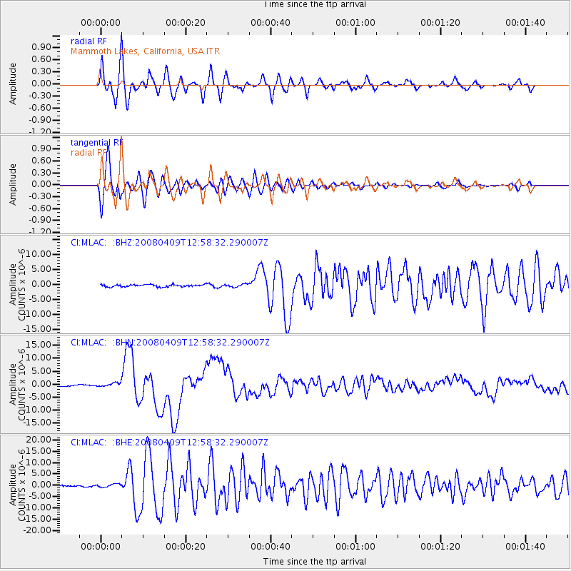
MLAC Mammoth Lakes, California, USA - Earthquake Result Viewer
*The percent match for this event was below the threshold and hence no stack was calculated.
| Earthquake location: |
Loyalty Islands |
| Earthquake latitude/longitude: |
-20.1/168.9 |
| Earthquake time(UTC): |
2008/04/09 (100) 12:46:12 GMT |
| Earthquake Depth: |
33 km |
| Earthquake Magnitude: |
6.3 MB, 7.3 MS, 7.3 MW, 7.3 MW |
| Earthquake Catalog/Contributor: |
WHDF/NEIC |
|
| Network: |
CI Caltech Regional Seismic Network |
| Station: |
MLAC Mammoth Lakes, California, USA |
| Lat/Lon: |
37.63 N/118.84 W |
| Elevation: |
2134 m |
|
| Distance: |
88.9 deg |
| Az: |
49.147 deg |
| Baz: |
243.578 deg |
| Ray Param: |
$rayparam |
*The percent match for this event was below the threshold and hence was not used in the summary stack. |
|
| Radial Match: |
86.96845 % |
| Radial Bump: |
400 |
| Transverse Match: |
84.10056 % |
| Transverse Bump: |
400 |
| SOD ConfigId: |
2504 |
| Insert Time: |
2010-02-26 00:39:09.304 +0000 |
| GWidth: |
2.5 |
| Max Bumps: |
400 |
| Tol: |
0.001 |
|
Signal To Noise
| Channel | StoN | STA | LTA |
| CI:MLAC: :BHN:20080409T12:58:32.290007Z | 2.8524766 | 8.064672E-7 | 2.8272527E-7 |
| CI:MLAC: :BHE:20080409T12:58:32.290007Z | 2.7564273 | 7.4295997E-7 | 2.695373E-7 |
| CI:MLAC: :BHZ:20080409T12:58:32.290007Z | 1.4190305 | 5.083931E-7 | 3.582679E-7 |
| Arrivals |
| Ps | |
| PpPs | |
| PsPs/PpSs | |


