You are here: Home > Network List > US - United States National Seismic Network Stations List
> Station ISCO Idaho Springs, Colorado, USA > Earthquake Result Viewer
ISCO Idaho Springs, Colorado, USA - Earthquake Result Viewer
| Earthquake location: |
Near Coast Of Peru |
| Earthquake latitude/longitude: |
-13.3/-76.5 |
| Earthquake time(UTC): |
2007/08/16 (228) 00:02:41 GMT |
| Earthquake Depth: |
40 km |
| Earthquake Magnitude: |
5.6 MB |
| Earthquake Catalog/Contributor: |
WHDF/NEIC |
|
| Network: |
US United States National Seismic Network |
| Station: |
ISCO Idaho Springs, Colorado, USA |
| Lat/Lon: |
39.80 N/105.61 W |
| Elevation: |
2743 m |
|
| Distance: |
59.3 deg |
| Az: |
334.156 deg |
| Baz: |
146.567 deg |
| Ray Param: |
0.06217837 |
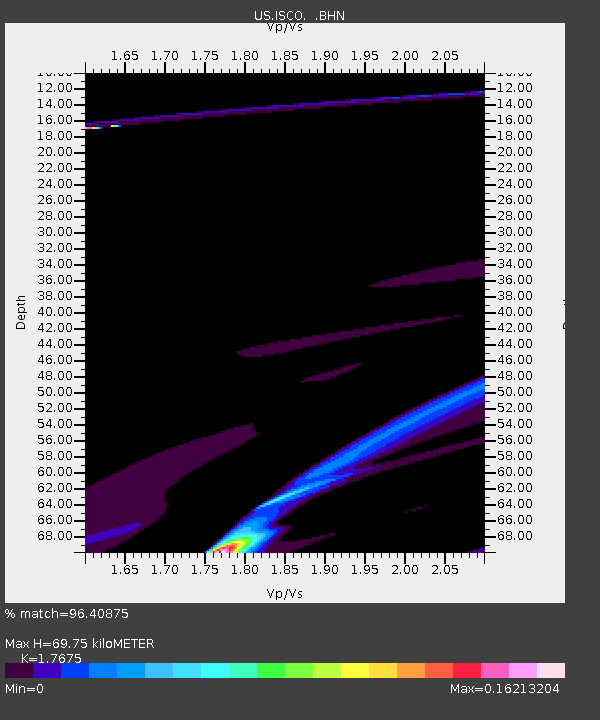
| Estimated Moho Depth: |
69.75 km |
| Estimated Crust Vp/Vs: |
1.77 |
| Assumed Crust Vp: |
6.159 km/s |
| Estimated Crust Vs: |
3.484 km/s |
| Estimated Crust Poisson's Ratio: |
0.26 |
|
| Radial Match: |
96.40875 % |
| Radial Bump: |
392 |
| Transverse Match: |
89.72194 % |
| Transverse Bump: |
374 |
| SOD ConfigId: |
2564 |
| Insert Time: |
2010-03-05 06:07:56.430 +0000 |
| GWidth: |
2.5 |
| Max Bumps: |
400 |
| Tol: |
0.001 |
|

Signal To Noise
| Channel | StoN | STA | LTA |
| US:ISCO: :BHN:20070816T00:12:08.498025Z | 1.8402058 | 4.7923764E-5 | 2.6042613E-5 |
| US:ISCO: :BHE:20070816T00:12:08.499001Z | 1.3877287 | 9.3230345E-5 | 6.718197E-5 |
| US:ISCO: :BHZ:20070816T00:12:08.499001Z | 1.6888272 | 1.9929251E-4 | 1.18006465E-4 |
| Arrivals |
| Ps | 9.1 SECOND |
| PpPs | 30 SECOND |
| PsPs/PpSs | 39 SECOND |


