You are here: Home > Network List > WY - Yellowstone Wyoming Seismic Network Stations List
> Station YHH Holmes Hill, YNP, WY, USA > Earthquake Result Viewer
YHH Holmes Hill, YNP, WY, USA - Earthquake Result Viewer
| Earthquake location: |
Off Coast Of Central Chile |
| Earthquake latitude/longitude: |
-29.7/-72.1 |
| Earthquake time(UTC): |
2015/09/19 (262) 05:06:47 GMT |
| Earthquake Depth: |
10 km |
| Earthquake Magnitude: |
5.8 MWR |
| Earthquake Catalog/Contributor: |
NEIC PDE/NEIC COMCAT |
|
| Network: |
WY Yellowstone Wyoming Seismic Network |
| Station: |
YHH Holmes Hill, YNP, WY, USA |
| Lat/Lon: |
44.79 N/110.85 W |
| Elevation: |
2717 m |
|
| Distance: |
82.1 deg |
| Az: |
333.269 deg |
| Baz: |
146.645 deg |
| Ray Param: |
0.047139045 |
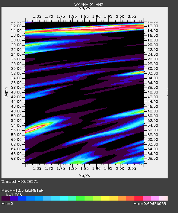
| Estimated Moho Depth: |
12.5 km |
| Estimated Crust Vp/Vs: |
1.88 |
| Assumed Crust Vp: |
6.35 km/s |
| Estimated Crust Vs: |
3.369 km/s |
| Estimated Crust Poisson's Ratio: |
0.30 |
|
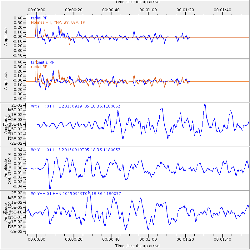
| Radial Match: |
93.28271 % |
| Radial Bump: |
341 |
| Transverse Match: |
87.015144 % |
| Transverse Bump: |
400 |
| SOD ConfigId: |
1156111 |
| Insert Time: |
2015-10-03 05:37:18.639 +0000 |
| GWidth: |
2.5 |
| Max Bumps: |
400 |
| Tol: |
0.001 |
|
Signal To Noise
| Channel | StoN | STA | LTA |
| WY:YHH:01:HHZ:20150919T05:18:36.118005Z | 2.153203 | 3.1551894E-9 | 1.4653468E-9 |
| WY:YHH:01:HHN:20150919T05:18:36.118005Z | 0.8418819 | 1.4241112E-9 | 1.6915808E-9 |
| WY:YHH:01:HHE:20150919T05:18:36.118005Z | 1.6727217 | 2.8863403E-9 | 1.7255352E-9 |
| Arrivals |
| Ps | 1.8 SECOND |
| PpPs | 5.5 SECOND |
| PsPs/PpSs | 7.3 SECOND |


