You are here: Home > Network List > US - United States National Seismic Network Stations List
> Station ISCO Idaho Springs, Colorado, USA > Earthquake Result Viewer
ISCO Idaho Springs, Colorado, USA - Earthquake Result Viewer
| Earthquake location: |
East Of Kuril Islands |
| Earthquake latitude/longitude: |
46.2/154.5 |
| Earthquake time(UTC): |
2007/01/13 (013) 04:23:21 GMT |
| Earthquake Depth: |
10 km |
| Earthquake Magnitude: |
7.3 MB, 8.2 MS, 8.1 MW, 7.9 MW |
| Earthquake Catalog/Contributor: |
WHDF/NEIC |
|
| Network: |
US United States National Seismic Network |
| Station: |
ISCO Idaho Springs, Colorado, USA |
| Lat/Lon: |
39.80 N/105.61 W |
| Elevation: |
2743 m |
|
| Distance: |
68.4 deg |
| Az: |
54.696 deg |
| Baz: |
312.677 deg |
| Ray Param: |
0.056300987 |
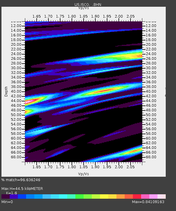
| Estimated Moho Depth: |
44.5 km |
| Estimated Crust Vp/Vs: |
1.60 |
| Assumed Crust Vp: |
6.159 km/s |
| Estimated Crust Vs: |
3.849 km/s |
| Estimated Crust Poisson's Ratio: |
0.18 |
|
| Radial Match: |
96.636246 % |
| Radial Bump: |
383 |
| Transverse Match: |
84.723305 % |
| Transverse Bump: |
400 |
| SOD ConfigId: |
2564 |
| Insert Time: |
2010-03-05 06:08:29.823 +0000 |
| GWidth: |
2.5 |
| Max Bumps: |
400 |
| Tol: |
0.001 |
|

Signal To Noise
| Channel | StoN | STA | LTA |
| US:ISCO: :BHN:20070113T04:33:51.975002Z | 3.5800662 | 4.349181E-7 | 1.2148325E-7 |
| US:ISCO: :BHE:20070113T04:33:51.975002Z | 4.036895 | 5.7830357E-7 | 1.4325455E-7 |
| US:ISCO: :BHZ:20070113T04:33:51.975002Z | 12.916547 | 1.8987288E-6 | 1.4699972E-7 |
| Arrivals |
| Ps | 4.5 SECOND |
| PpPs | 18 SECOND |
| PsPs/PpSs | 23 SECOND |


