You are here: Home > Network List > TA - USArray Transportable Network (new EarthScope stations) Stations List
> Station L04D Klamath Falls, OR, USA > Earthquake Result Viewer
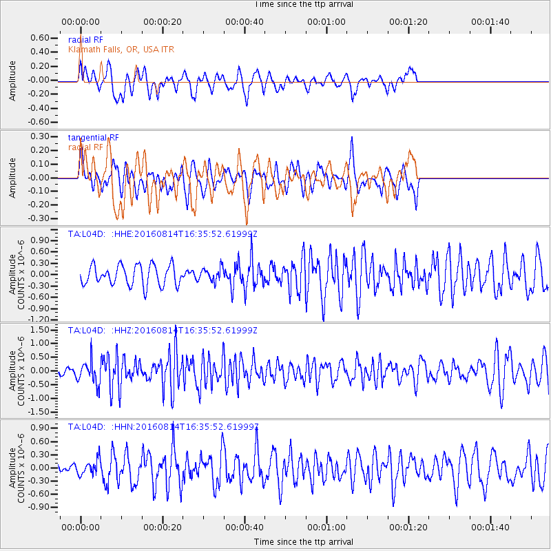
L04D Klamath Falls, OR, USA - Earthquake Result Viewer
*The percent match for this event was below the threshold and hence no stack was calculated.
| Earthquake location: |
Rat Islands, Aleutian Islands |
| Earthquake latitude/longitude: |
51.5/179.6 |
| Earthquake time(UTC): |
2016/08/14 (227) 16:28:55 GMT |
| Earthquake Depth: |
65 km |
| Earthquake Magnitude: |
5.6 MWB, 5.5 MI, 5.6 ML |
| Earthquake Catalog/Contributor: |
NEIC PDE/NEIC COMCAT |
|
| Network: |
TA USArray Transportable Network (new EarthScope stations) |
| Station: |
L04D Klamath Falls, OR, USA |
| Lat/Lon: |
42.22 N/122.30 W |
| Elevation: |
1437 m |
|
| Distance: |
39.9 deg |
| Az: |
79.941 deg |
| Baz: |
304.125 deg |
| Ray Param: |
$rayparam |
*The percent match for this event was below the threshold and hence was not used in the summary stack. |
|
| Radial Match: |
67.31463 % |
| Radial Bump: |
400 |
| Transverse Match: |
54.821175 % |
| Transverse Bump: |
361 |
| SOD ConfigId: |
11737051 |
| Insert Time: |
2019-04-25 06:46:58.820 +0000 |
| GWidth: |
2.5 |
| Max Bumps: |
400 |
| Tol: |
0.001 |
|
Signal To Noise
| Channel | StoN | STA | LTA |
| TA:L04D: :HHZ:20160814T16:35:52.61999Z | 2.796628 | 4.1334604E-7 | 1.4780159E-7 |
| TA:L04D: :HHN:20160814T16:35:52.61999Z | 1.2885642 | 1.7378085E-7 | 1.3486395E-7 |
| TA:L04D: :HHE:20160814T16:35:52.61999Z | 0.64297205 | 1.7092425E-7 | 2.6583464E-7 |
| Arrivals |
| Ps | |
| PpPs | |
| PsPs/PpSs | |


