You are here: Home > Network List > TJ - Tajikistan National Seismic Network Stations List
> Station SHAA Shaartuz, Tajikistan > Earthquake Result Viewer
SHAA Shaartuz, Tajikistan - Earthquake Result Viewer
| Earthquake location: |
Rat Islands, Aleutian Islands |
| Earthquake latitude/longitude: |
51.5/179.6 |
| Earthquake time(UTC): |
2016/08/14 (227) 16:28:55 GMT |
| Earthquake Depth: |
65 km |
| Earthquake Magnitude: |
5.6 MWB, 5.5 MI, 5.6 ML |
| Earthquake Catalog/Contributor: |
NEIC PDE/NEIC COMCAT |
|
| Network: |
TJ Tajikistan National Seismic Network |
| Station: |
SHAA Shaartuz, Tajikistan |
| Lat/Lon: |
37.56 N/68.12 E |
| Elevation: |
868 m |
|
| Distance: |
73.0 deg |
| Az: |
309.318 deg |
| Baz: |
37.446 deg |
| Ray Param: |
0.053171992 |
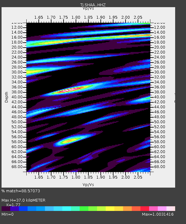
| Estimated Moho Depth: |
37.0 km |
| Estimated Crust Vp/Vs: |
1.77 |
| Assumed Crust Vp: |
6.213 km/s |
| Estimated Crust Vs: |
3.51 km/s |
| Estimated Crust Poisson's Ratio: |
0.27 |
|
| Radial Match: |
88.57073 % |
| Radial Bump: |
400 |
| Transverse Match: |
83.142876 % |
| Transverse Bump: |
400 |
| SOD ConfigId: |
11737051 |
| Insert Time: |
2019-04-25 06:47:28.219 +0000 |
| GWidth: |
2.5 |
| Max Bumps: |
400 |
| Tol: |
0.001 |
|
Signal To Noise
| Channel | StoN | STA | LTA |
| TJ:SHAA: :HHZ:20160814T16:39:47.15002Z | 3.465478 | 4.5729223E-7 | 1.3195645E-7 |
| TJ:SHAA: :HHN:20160814T16:39:47.15002Z | 1.3693715 | 1.4032149E-7 | 1.02471446E-7 |
| TJ:SHAA: :HHE:20160814T16:39:47.15002Z | 1.8988326 | 2.6346726E-7 | 1.3875223E-7 |
| Arrivals |
| Ps | 4.7 SECOND |
| PpPs | 16 SECOND |
| PsPs/PpSs | 21 SECOND |


