You are here: Home > Network List > UW - Pacific Northwest Regional Seismic Network Stations List
> Station PASS Maple Falls, WA, USA > Earthquake Result Viewer
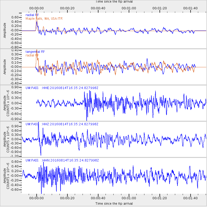
PASS Maple Falls, WA, USA - Earthquake Result Viewer
*The percent match for this event was below the threshold and hence no stack was calculated.
| Earthquake location: |
Rat Islands, Aleutian Islands |
| Earthquake latitude/longitude: |
51.5/179.6 |
| Earthquake time(UTC): |
2016/08/14 (227) 16:28:55 GMT |
| Earthquake Depth: |
65 km |
| Earthquake Magnitude: |
5.6 MWB, 5.5 MI, 5.6 ML |
| Earthquake Catalog/Contributor: |
NEIC PDE/NEIC COMCAT |
|
| Network: |
UW Pacific Northwest Regional Seismic Network |
| Station: |
PASS Maple Falls, WA, USA |
| Lat/Lon: |
49.00 N/122.09 W |
| Elevation: |
174 m |
|
| Distance: |
36.5 deg |
| Az: |
70.354 deg |
| Baz: |
296.736 deg |
| Ray Param: |
$rayparam |
*The percent match for this event was below the threshold and hence was not used in the summary stack. |
|
| Radial Match: |
71.158775 % |
| Radial Bump: |
400 |
| Transverse Match: |
60.89948 % |
| Transverse Bump: |
400 |
| SOD ConfigId: |
11737051 |
| Insert Time: |
2019-04-25 06:48:05.301 +0000 |
| GWidth: |
2.5 |
| Max Bumps: |
400 |
| Tol: |
0.001 |
|
Signal To Noise
| Channel | StoN | STA | LTA |
| UW:PASS: :HHZ:20160814T16:35:24.827998Z | 3.8575292 | 4.4058243E-7 | 1.1421364E-7 |
| UW:PASS: :HHN:20160814T16:35:24.827998Z | 2.3735504 | 2.5608955E-7 | 1.0789302E-7 |
| UW:PASS: :HHE:20160814T16:35:24.827998Z | 3.0656812 | 3.388022E-7 | 1.1051449E-7 |
| Arrivals |
| Ps | |
| PpPs | |
| PsPs/PpSs | |


