You are here: Home > Network List > US - United States National Seismic Network Stations List
> Station ISCO Idaho Springs, Colorado, USA > Earthquake Result Viewer
ISCO Idaho Springs, Colorado, USA - Earthquake Result Viewer

| Earthquake location: |
Samoa Islands Region |
| Earthquake latitude/longitude: |
-15.2/-172.6 |
| Earthquake time(UTC): |
2009/08/30 (242) 14:51:32 GMT |
| Earthquake Depth: |
11 km |
| Earthquake Magnitude: |
6.4 MB, 6.3 MS, 6.6 MW, 6.6 MW |
| Earthquake Catalog/Contributor: |
WHDF/NEIC |
|
| Network: |
US United States National Seismic Network |
| Station: |
ISCO Idaho Springs, Colorado, USA |
| Lat/Lon: |
39.80 N/105.61 W |
| Elevation: |
2743 m |
|
| Distance: |
82.8 deg |
| Az: |
45.603 deg |
| Baz: |
243.55 deg |
| Ray Param: |
0.04660983 |
| Estimated Moho Depth: |
46.5 km |
| Estimated Crust Vp/Vs: |
1.75 |
| Assumed Crust Vp: |
6.159 km/s |
| Estimated Crust Vs: |
3.524 km/s |
| Estimated Crust Poisson's Ratio: |
0.26 |
|
| Radial Match: |
94.60203 % |
| Radial Bump: |
400 |
| Transverse Match: |
90.65384 % |
| Transverse Bump: |
400 |
| SOD ConfigId: |
2622 |
| Insert Time: |
2010-03-05 06:09:52.503 +0000 |
| GWidth: |
2.5 |
| Max Bumps: |
400 |
| Tol: |
0.001 |
|
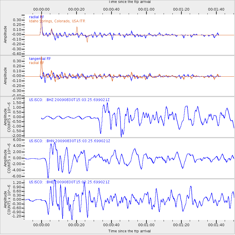
Signal To Noise
| Channel | StoN | STA | LTA |
| US:ISCO: :BHN:20090830T15:03:25.699021Z | 29.121014 | 2.401662E-6 | 8.2471786E-8 |
| US:ISCO: :BHE:20090830T15:03:25.699021Z | 5.610142 | 3.800461E-7 | 6.774269E-8 |
| US:ISCO: :BHZ:20090830T15:03:25.699021Z | 6.576657 | 6.323697E-7 | 9.615366E-8 |
| Arrivals |
| Ps | 5.8 SECOND |
| PpPs | 20 SECOND |
| PsPs/PpSs | 26 SECOND |


