You are here: Home > Network List > CI - Caltech Regional Seismic Network Stations List
> Station MPM Manuel Prospect Mine, California, USA > Earthquake Result Viewer
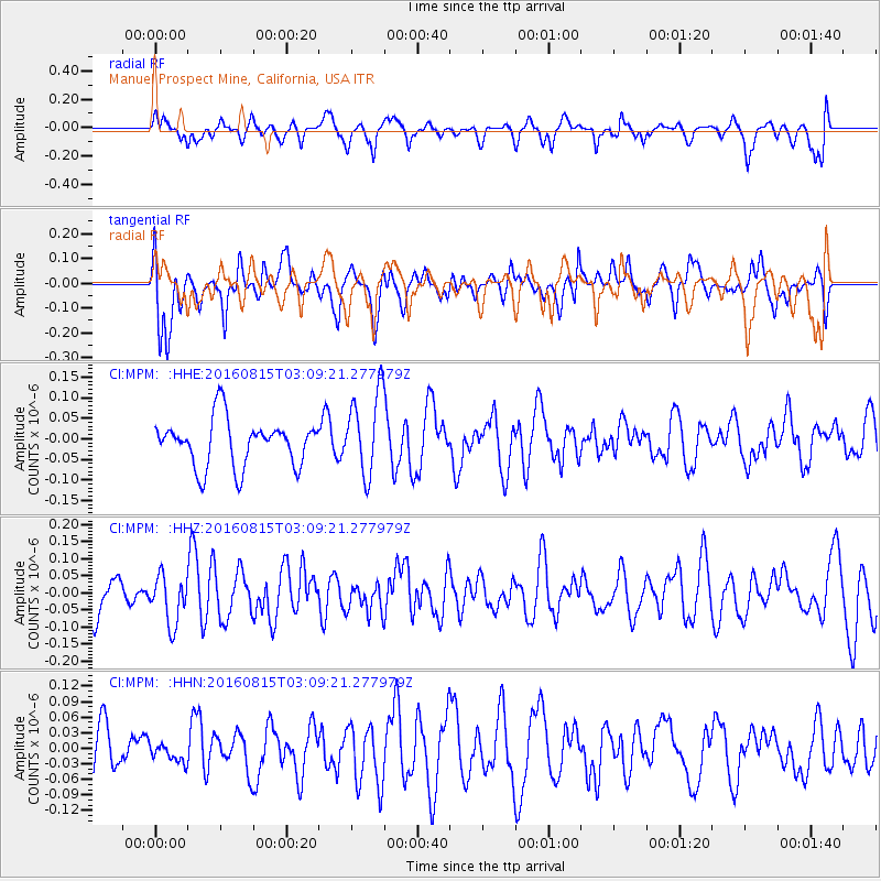
MPM Manuel Prospect Mine, California, USA - Earthquake Result Viewer
*The percent match for this event was below the threshold and hence no stack was calculated.
| Earthquake location: |
Southern Peru |
| Earthquake latitude/longitude: |
-15.7/-72.0 |
| Earthquake time(UTC): |
2016/08/15 (228) 02:59:00 GMT |
| Earthquake Depth: |
20 km |
| Earthquake Magnitude: |
5.5 mwb |
| Earthquake Catalog/Contributor: |
NEIC PDE/ |
|
| Network: |
CI Caltech Regional Seismic Network |
| Station: |
MPM Manuel Prospect Mine, California, USA |
| Lat/Lon: |
36.06 N/117.49 W |
| Elevation: |
185 m |
|
| Distance: |
67.0 deg |
| Az: |
321.141 deg |
| Baz: |
131.761 deg |
| Ray Param: |
$rayparam |
*The percent match for this event was below the threshold and hence was not used in the summary stack. |
|
| Radial Match: |
56.649807 % |
| Radial Bump: |
400 |
| Transverse Match: |
59.952984 % |
| Transverse Bump: |
400 |
| SOD ConfigId: |
11737051 |
| Insert Time: |
2019-04-25 06:52:08.265 +0000 |
| GWidth: |
2.5 |
| Max Bumps: |
400 |
| Tol: |
0.001 |
|
Signal To Noise
| Channel | StoN | STA | LTA |
| CI:MPM: :HHZ:20160815T03:09:21.277979Z | 0.93441933 | 7.084012E-8 | 7.581192E-8 |
| CI:MPM: :HHN:20160815T03:09:21.277979Z | 0.3782116 | 1.585076E-8 | 4.190977E-8 |
| CI:MPM: :HHE:20160815T03:09:21.277979Z | 1.7705303 | 1.010425E-7 | 5.7069062E-8 |
| Arrivals |
| Ps | |
| PpPs | |
| PsPs/PpSs | |


