You are here: Home > Network List > N4 - Central and EAstern US Network Stations List
> Station U56A King, NC, USA > Earthquake Result Viewer
U56A King, NC, USA - Earthquake Result Viewer
| Earthquake location: |
Southern Peru |
| Earthquake latitude/longitude: |
-15.7/-72.0 |
| Earthquake time(UTC): |
2016/08/15 (228) 02:59:00 GMT |
| Earthquake Depth: |
20 km |
| Earthquake Magnitude: |
5.5 mwb |
| Earthquake Catalog/Contributor: |
NEIC PDE/ |
|
| Network: |
N4 Central and EAstern US Network |
| Station: |
U56A King, NC, USA |
| Lat/Lon: |
36.35 N/80.38 W |
| Elevation: |
363 m |
|
| Distance: |
52.3 deg |
| Az: |
351.465 deg |
| Baz: |
169.8 deg |
| Ray Param: |
0.06680913 |
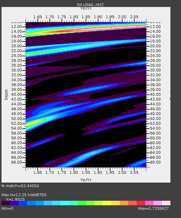
| Estimated Moho Depth: |
12.25 km |
| Estimated Crust Vp/Vs: |
1.95 |
| Assumed Crust Vp: |
6.159 km/s |
| Estimated Crust Vs: |
3.154 km/s |
| Estimated Crust Poisson's Ratio: |
0.32 |
|
| Radial Match: |
82.44004 % |
| Radial Bump: |
399 |
| Transverse Match: |
56.22974 % |
| Transverse Bump: |
400 |
| SOD ConfigId: |
11737051 |
| Insert Time: |
2019-04-25 06:55:34.279 +0000 |
| GWidth: |
2.5 |
| Max Bumps: |
400 |
| Tol: |
0.001 |
|

Signal To Noise
| Channel | StoN | STA | LTA |
| N4:U56A: :HHZ:20160815T03:07:40.190027Z | 4.119466 | 4.5027042E-7 | 1.0930311E-7 |
| N4:U56A: :HHN:20160815T03:07:40.190027Z | 3.2425208 | 2.5052967E-7 | 7.726386E-8 |
| N4:U56A: :HHE:20160815T03:07:40.190027Z | 0.92173463 | 6.383688E-8 | 6.925733E-8 |
| Arrivals |
| Ps | 2.0 SECOND |
| PpPs | 5.6 SECOND |
| PsPs/PpSs | 7.6 SECOND |


