You are here: Home > Network List > GS - US Geological Survey Networks Stations List
> Station DEC07 Decatur Surface Seismic Site, Decatur, IL, USA > Earthquake Result Viewer
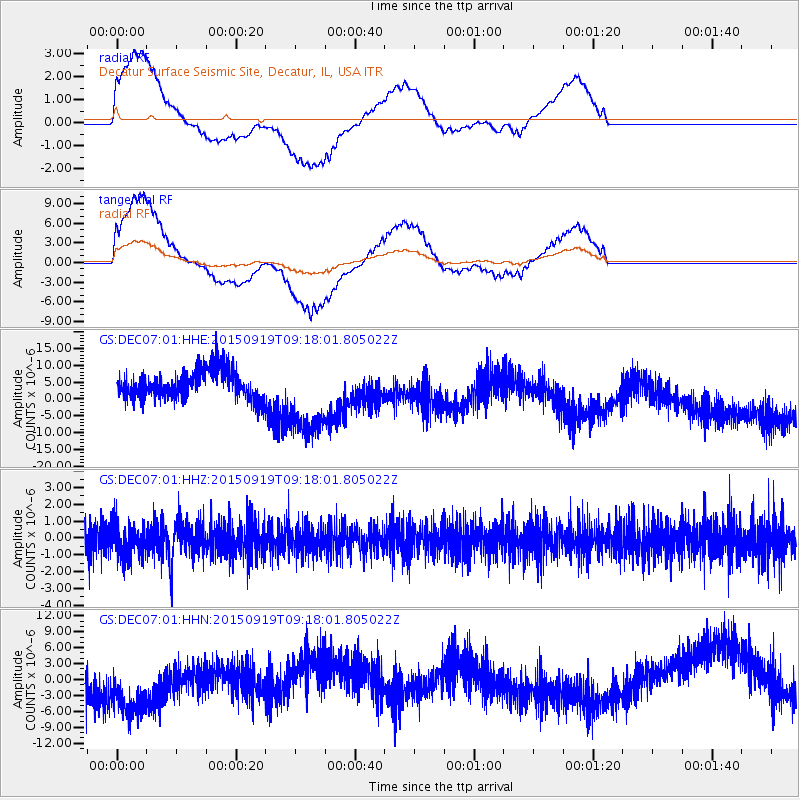
DEC07 Decatur Surface Seismic Site, Decatur, IL, USA - Earthquake Result Viewer
*The percent match for this event was below the threshold and hence no stack was calculated.
| Earthquake location: |
Near Coast Of Central Chile |
| Earthquake latitude/longitude: |
-31.1/-71.6 |
| Earthquake time(UTC): |
2015/09/19 (262) 09:07:08 GMT |
| Earthquake Depth: |
23 km |
| Earthquake Magnitude: |
6.1 MWP |
| Earthquake Catalog/Contributor: |
NEIC PDE/NEIC COMCAT |
|
| Network: |
GS US Geological Survey Networks |
| Station: |
DEC07 Decatur Surface Seismic Site, Decatur, IL, USA |
| Lat/Lon: |
39.86 N/88.90 W |
| Elevation: |
212 m |
|
| Distance: |
72.4 deg |
| Az: |
346.117 deg |
| Baz: |
164.492 deg |
| Ray Param: |
$rayparam |
*The percent match for this event was below the threshold and hence was not used in the summary stack. |
|
| Radial Match: |
55.777447 % |
| Radial Bump: |
400 |
| Transverse Match: |
54.38955 % |
| Transverse Bump: |
400 |
| SOD ConfigId: |
1156111 |
| Insert Time: |
2015-10-03 09:28:24.890 +0000 |
| GWidth: |
2.5 |
| Max Bumps: |
400 |
| Tol: |
0.001 |
|
Signal To Noise
| Channel | StoN | STA | LTA |
| GS:DEC07:01:HHZ:20150919T09:18:01.805022Z | 1.2649996 | 1.0136238E-6 | 8.012839E-7 |
| GS:DEC07:01:HHN:20150919T09:18:01.805022Z | 2.2328074 | 7.065871E-6 | 3.1645684E-6 |
| GS:DEC07:01:HHE:20150919T09:18:01.805022Z | 2.8530018 | 1.2030689E-5 | 4.2168526E-6 |
| Arrivals |
| Ps | |
| PpPs | |
| PsPs/PpSs | |


