You are here: Home > Network List > N4 - Central and EAstern US Network Stations List
> Station Y57A Sumter, SC, USA > Earthquake Result Viewer
Y57A Sumter, SC, USA - Earthquake Result Viewer
| Earthquake location: |
Southern Peru |
| Earthquake latitude/longitude: |
-15.7/-72.0 |
| Earthquake time(UTC): |
2016/08/15 (228) 02:59:00 GMT |
| Earthquake Depth: |
20 km |
| Earthquake Magnitude: |
5.5 mwb |
| Earthquake Catalog/Contributor: |
NEIC PDE/ |
|
| Network: |
N4 Central and EAstern US Network |
| Station: |
Y57A Sumter, SC, USA |
| Lat/Lon: |
34.02 N/80.39 W |
| Elevation: |
56 m |
|
| Distance: |
50.0 deg |
| Az: |
350.919 deg |
| Baz: |
169.453 deg |
| Ray Param: |
0.06829499 |
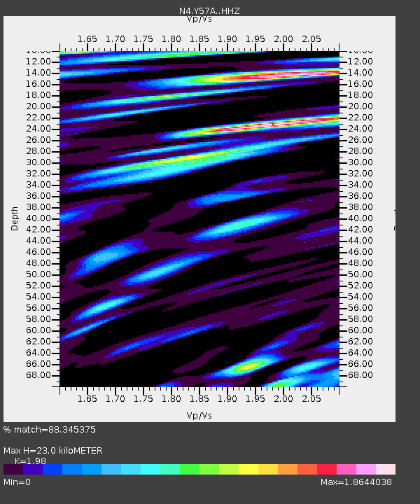
| Estimated Moho Depth: |
23.0 km |
| Estimated Crust Vp/Vs: |
1.98 |
| Assumed Crust Vp: |
6.419 km/s |
| Estimated Crust Vs: |
3.242 km/s |
| Estimated Crust Poisson's Ratio: |
0.33 |
|
| Radial Match: |
88.345375 % |
| Radial Bump: |
400 |
| Transverse Match: |
65.488434 % |
| Transverse Bump: |
400 |
| SOD ConfigId: |
11737051 |
| Insert Time: |
2019-04-25 06:55:49.503 +0000 |
| GWidth: |
2.5 |
| Max Bumps: |
400 |
| Tol: |
0.001 |
|

Signal To Noise
| Channel | StoN | STA | LTA |
| N4:Y57A: :HHZ:20160815T03:07:23.070001Z | 8.094383 | 5.400741E-7 | 6.672208E-8 |
| N4:Y57A: :HHN:20160815T03:07:23.070001Z | 3.2348607 | 4.6567405E-7 | 1.4395489E-7 |
| N4:Y57A: :HHE:20160815T03:07:23.070001Z | 1.2777286 | 1.4892483E-7 | 1.16554354E-7 |
| Arrivals |
| Ps | 3.7 SECOND |
| PpPs | 10 SECOND |
| PsPs/PpSs | 14 SECOND |


